|
|
|||||||||||||||||
| Point ID: 8891 | Downloads | Plots | Site Data | Code: 70548 |
|
|
|||||||||||||||||
| Download | |
|---|---|
| Site Descriptor Information | Site Time Series Data |
| Link to all available data | |
|
|
| View: | Statistics | Time Series |
| Units: | mm |
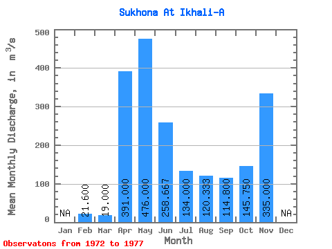
| Statistic | Jan | Feb | Mar | Apr | May | Jun | Jul | Aug | Sep | Oct | Nov | Dec | Annual |
|---|---|---|---|---|---|---|---|---|---|---|---|---|---|
| Mean | 21.60 | 19.00 | 391.00 | 476.00 | 258.67 | 134.00 | 120.33 | 114.80 | 145.75 | 335.00 | |||
| Standard Deviation | 193.07 | 174.12 | 41.58 | 33.47 | 28.22 | 69.65 | |||||||
| Min | 21.60 | 19.00 | 391.00 | 286.00 | 123.00 | 102.00 | 94.00 | 94.40 | 96.50 | 335.00 | |||
| Max | 21.60 | 19.00 | 391.00 | 672.00 | 455.00 | 181.00 | 158.00 | 147.00 | 195.00 | 335.00 | |||
| Coefficient of Variation | 0.41 | 0.67 | 0.31 | 0.28 | 0.25 | 0.48 |
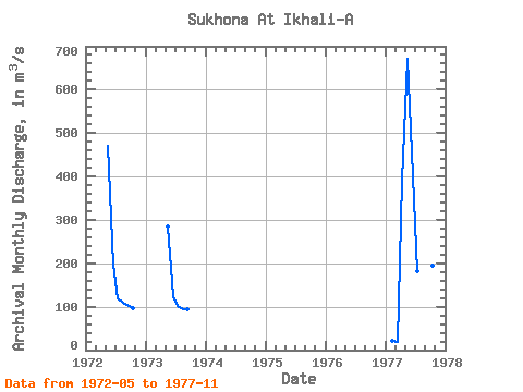
| Year | Jan | Feb | Mar | Apr | May | Jun | Jul | Aug | Sep | Oct | Nov | Dec | Annual | 1972 | 470.00 | 198.00 | 119.00 | 109.00 | 103.00 | 96.50 | 1973 | 286.00 | 123.00 | 102.00 | 94.00 | 94.40 | 1977 | 21.60 | 19.00 | 391.00 | 672.00 | 455.00 | 181.00 | 158.00 | 147.00 | 195.00 | 335.00 |
|---|
 Return to R-Arctic Net Home Page