|
|
|||||||||||||||||
| Point ID: 8891 | Downloads | Plots | Site Data | Code: 70548 |
|
|
|||||||||||||||||
| Download | |
|---|---|
| Site Descriptor Information | Site Time Series Data |
| Link to all available data | |
|
|
| View: | Statistics | Time Series |
| Units: | m3/s |
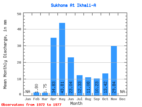
| Statistic | Jan | Feb | Mar | Apr | May | Jun | Jul | Aug | Sep | Oct | Nov | Dec | Annual |
|---|---|---|---|---|---|---|---|---|---|---|---|---|---|
| Mean | 1.81 | 1.75 | 34.83 | 43.80 | 23.04 | 12.33 | 11.07 | 10.22 | 13.41 | 29.84 | |||
| Standard Deviation | 17.77 | 15.51 | 3.83 | 3.08 | 2.51 | 6.41 | |||||||
| Min | 1.81 | 1.75 | 34.83 | 26.32 | 10.96 | 9.39 | 8.65 | 8.41 | 8.88 | 29.84 | |||
| Max | 1.81 | 1.75 | 34.83 | 61.84 | 40.53 | 16.66 | 14.54 | 13.09 | 17.95 | 29.84 | |||
| Coefficient of Variation | 0.41 | 0.67 | 0.31 | 0.28 | 0.25 | 0.48 |
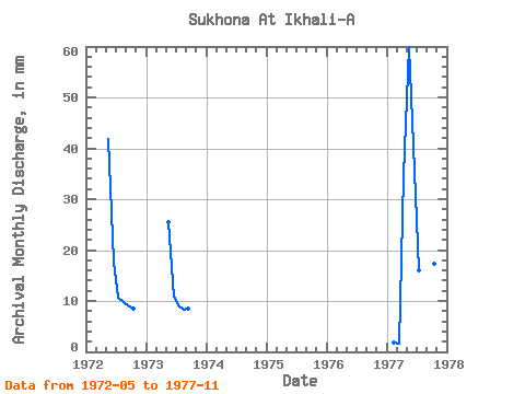
| Year | Jan | Feb | Mar | Apr | May | Jun | Jul | Aug | Sep | Oct | Nov | Dec | Annual | 1972 | 43.25 | 17.64 | 10.95 | 10.03 | 9.17 | 8.88 | 1973 | 26.32 | 10.96 | 9.39 | 8.65 | 8.41 | 1977 | 1.81 | 1.75 | 34.83 | 61.84 | 40.53 | 16.66 | 14.54 | 13.09 | 17.95 | 29.84 |
|---|
 Return to R-Arctic Net Home Page