|
|
|||||||||||||||||
| Point ID: 8887 | Downloads | Plots | Site Data | Code: 70537 |
|
|
|||||||||||||||||
| Download | |
|---|---|
| Site Descriptor Information | Site Time Series Data |
| Link to all available data | |
|
|
| View: | Statistics | Time Series |
| Units: | mm |
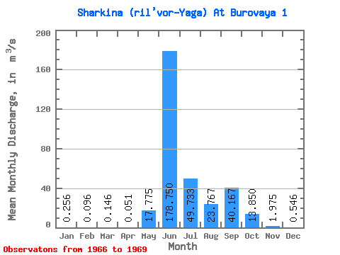
| Statistic | Jan | Feb | Mar | Apr | May | Jun | Jul | Aug | Sep | Oct | Nov | Dec | Annual |
|---|---|---|---|---|---|---|---|---|---|---|---|---|---|
| Mean | 0.26 | 0.10 | 0.15 | 0.05 | 17.77 | 178.75 | 49.73 | 23.77 | 40.17 | 13.85 | 1.98 | 0.55 | 30.88 |
| Standard Deviation | 0.29 | 0.08 | 0.10 | 0.06 | 22.95 | 46.93 | 37.55 | 9.62 | 8.63 | 4.31 | 0.05 | 0.70 | 0.86 |
| Min | 0.05 | 0.04 | 0.07 | 0.01 | 1.55 | 112.00 | 24.60 | 12.90 | 30.50 | 10.80 | 1.94 | 0.05 | 30.27 |
| Max | 0.46 | 0.15 | 0.22 | 0.09 | 34.00 | 222.00 | 92.90 | 31.20 | 47.10 | 16.90 | 2.01 | 1.04 | 31.48 |
| Coefficient of Variation | 1.13 | 0.80 | 0.72 | 1.14 | 1.29 | 0.26 | 0.76 | 0.41 | 0.21 | 0.31 | 0.03 | 1.28 | 0.03 |
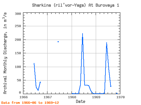
| Year | Jan | Feb | Mar | Apr | May | Jun | Jul | Aug | Sep | Oct | Nov | Dec | Annual | 1966 | 112.00 | 24.60 | 12.90 | 42.90 | 1967 | 192.00 | 1968 | 0.46 | 0.15 | 0.22 | 0.09 | 34.00 | 222.00 | 31.70 | 31.20 | 30.50 | 10.80 | 2.01 | 0.05 | 30.27 | 1969 | 0.05 | 0.04 | 0.07 | 0.01 | 1.55 | 189.00 | 92.90 | 27.20 | 47.10 | 16.90 | 1.94 | 1.04 | 31.48 |
|---|
 Return to R-Arctic Net Home Page