|
|
|||||||||||||||||
| Point ID: 8887 | Downloads | Plots | Site Data | Code: 70537 |
|
|
|||||||||||||||||
| Download | |
|---|---|
| Site Descriptor Information | Site Time Series Data |
| Link to all available data | |
|
|
| View: | Statistics | Time Series |
| Units: | m3/s |
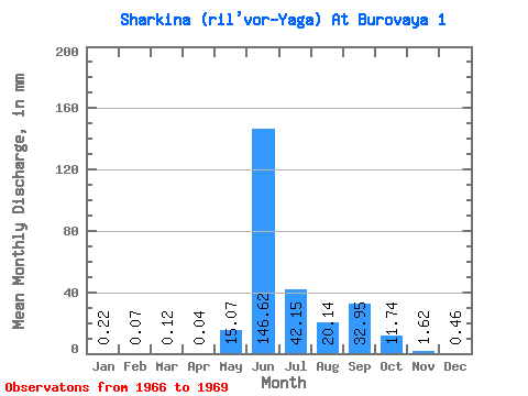
| Statistic | Jan | Feb | Mar | Apr | May | Jun | Jul | Aug | Sep | Oct | Nov | Dec | Annual |
|---|---|---|---|---|---|---|---|---|---|---|---|---|---|
| Mean | 0.22 | 0.07 | 0.12 | 0.04 | 15.06 | 146.62 | 42.15 | 20.14 | 32.95 | 11.74 | 1.62 | 0.46 | 308.36 |
| Standard Deviation | 0.24 | 0.06 | 0.09 | 0.05 | 19.45 | 38.49 | 31.82 | 8.15 | 7.08 | 3.66 | 0.04 | 0.59 | 8.60 |
| Min | 0.04 | 0.03 | 0.06 | 0.01 | 1.31 | 91.87 | 20.85 | 10.93 | 25.02 | 9.15 | 1.59 | 0.04 | 302.27 |
| Max | 0.39 | 0.12 | 0.19 | 0.07 | 28.81 | 182.10 | 78.73 | 26.44 | 38.63 | 14.32 | 1.65 | 0.88 | 314.44 |
| Coefficient of Variation | 1.13 | 0.80 | 0.72 | 1.14 | 1.29 | 0.26 | 0.76 | 0.41 | 0.21 | 0.31 | 0.03 | 1.28 | 0.03 |
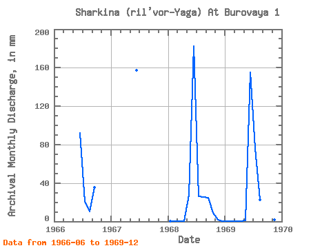
| Year | Jan | Feb | Mar | Apr | May | Jun | Jul | Aug | Sep | Oct | Nov | Dec | Annual | 1966 | 91.87 | 20.85 | 10.93 | 35.19 | 1967 | 157.49 | 1968 | 0.39 | 0.12 | 0.19 | 0.07 | 28.81 | 182.10 | 26.86 | 26.44 | 25.02 | 9.15 | 1.65 | 0.04 | 302.27 | 1969 | 0.04 | 0.03 | 0.06 | 0.01 | 1.31 | 155.03 | 78.73 | 23.05 | 38.63 | 14.32 | 1.59 | 0.88 | 314.44 |
|---|
 Return to R-Arctic Net Home Page