|
|
|||||||||||||||||
| Point ID: 8879 | Downloads | Plots | Site Data | Code: 70481 |
|
|
|||||||||||||||||
| Download | |
|---|---|
| Site Descriptor Information | Site Time Series Data |
| Link to all available data | |
|
|
| View: | Statistics | Time Series |
| Units: | mm |
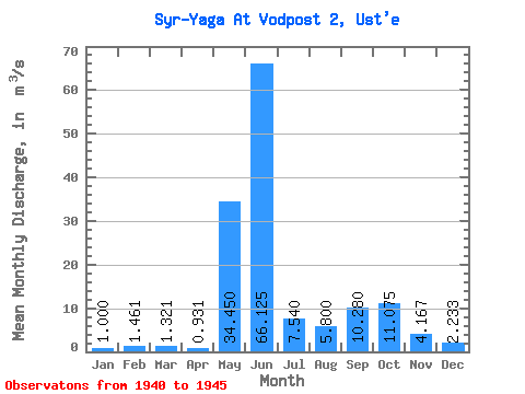
| Statistic | Jan | Feb | Mar | Apr | May | Jun | Jul | Aug | Sep | Oct | Nov | Dec | Annual |
|---|---|---|---|---|---|---|---|---|---|---|---|---|---|
| Mean | 1.00 | 1.46 | 1.32 | 0.93 | 34.45 | 66.12 | 7.54 | 5.80 | 10.28 | 11.07 | 4.17 | 2.23 | 16.73 |
| Standard Deviation | 39.67 | 42.21 | 3.39 | 3.51 | 7.00 | 10.15 | 2.22 | 1.06 | |||||
| Min | 1.00 | 1.46 | 1.32 | 0.93 | 6.40 | 11.70 | 3.60 | 3.70 | 4.80 | 2.80 | 1.80 | 1.10 | 16.73 |
| Max | 1.00 | 1.46 | 1.32 | 0.93 | 62.50 | 110.00 | 12.50 | 12.00 | 22.10 | 23.70 | 6.20 | 3.20 | 16.73 |
| Coefficient of Variation | 1.15 | 0.64 | 0.45 | 0.60 | 0.68 | 0.92 | 0.53 | 0.47 |
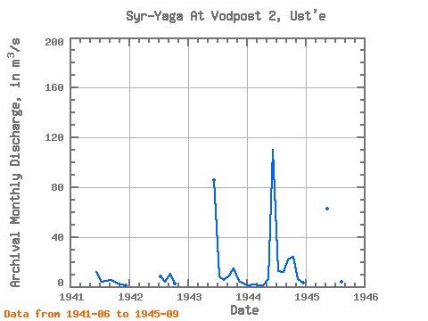
| Year | Jan | Feb | Mar | Apr | May | Jun | Jul | Aug | Sep | Oct | Nov | Dec | Annual | 1940 | 1941 | 11.70 | 3.60 | 4.40 | 5.40 | 2.90 | 1.80 | 1.10 | 1942 | 8.00 | 3.70 | 10.30 | 2.80 | 1943 | 85.60 | 8.30 | 5.10 | 8.80 | 14.90 | 4.50 | 2.40 | 1944 | 1.00 | 1.46 | 1.32 | 0.93 | 6.40 | 110.00 | 12.50 | 12.00 | 22.10 | 23.70 | 6.20 | 3.20 | 16.73 | 1945 | 62.50 | 57.20 | 5.30 | 3.80 | 4.80 |
|---|
 Return to R-Arctic Net Home Page