|
|
|||||||||||||||||
| Point ID: 8879 | Downloads | Plots | Site Data | Code: 70481 |
|
|
|||||||||||||||||
| Download | |
|---|---|
| Site Descriptor Information | Site Time Series Data |
| Link to all available data | |
|
|
| View: | Statistics | Time Series |
| Units: | m3/s |
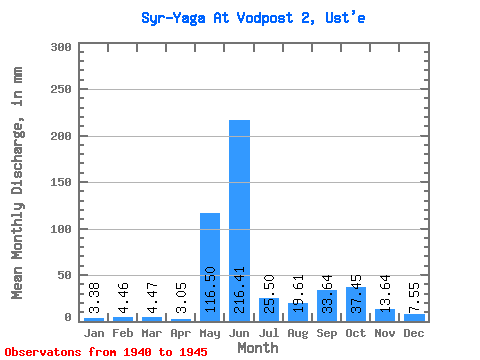
| Statistic | Jan | Feb | Mar | Apr | May | Jun | Jul | Aug | Sep | Oct | Nov | Dec | Annual |
|---|---|---|---|---|---|---|---|---|---|---|---|---|---|
| Mean | 3.38 | 4.50 | 4.46 | 3.05 | 116.49 | 216.41 | 25.50 | 19.61 | 33.64 | 37.45 | 13.64 | 7.55 | 666.84 |
| Standard Deviation | 134.13 | 138.15 | 11.46 | 11.87 | 22.89 | 34.34 | 7.26 | 3.58 | |||||
| Min | 3.38 | 4.50 | 4.46 | 3.05 | 21.64 | 38.29 | 12.17 | 12.51 | 15.71 | 9.47 | 5.89 | 3.72 | 666.84 |
| Max | 3.38 | 4.50 | 4.46 | 3.05 | 211.33 | 360.00 | 42.27 | 40.58 | 72.33 | 80.14 | 20.29 | 10.82 | 666.84 |
| Coefficient of Variation | 1.15 | 0.64 | 0.45 | 0.60 | 0.68 | 0.92 | 0.53 | 0.47 |
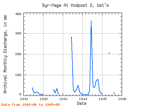
| Year | Jan | Feb | Mar | Apr | May | Jun | Jul | Aug | Sep | Oct | Nov | Dec | Annual | 1940 | 1941 | 38.29 | 12.17 | 14.88 | 17.67 | 9.81 | 5.89 | 3.72 | 1942 | 27.05 | 12.51 | 33.71 | 9.47 | 1943 | 280.14 | 28.07 | 17.25 | 28.80 | 50.38 | 14.73 | 8.12 | 1944 | 3.38 | 4.50 | 4.46 | 3.05 | 21.64 | 360.00 | 42.27 | 40.58 | 72.33 | 80.14 | 20.29 | 10.82 | 666.84 | 1945 | 211.33 | 187.20 | 17.92 | 12.85 | 15.71 |
|---|
 Return to R-Arctic Net Home Page