|
|
|||||||||||||||||
| Point ID: 8826 | Downloads | Plots | Site Data | Code: 70024 |
|
|
|||||||||||||||||
| Download | |
|---|---|
| Site Descriptor Information | Site Time Series Data |
| Link to all available data | |
| View: | Time Series | All |
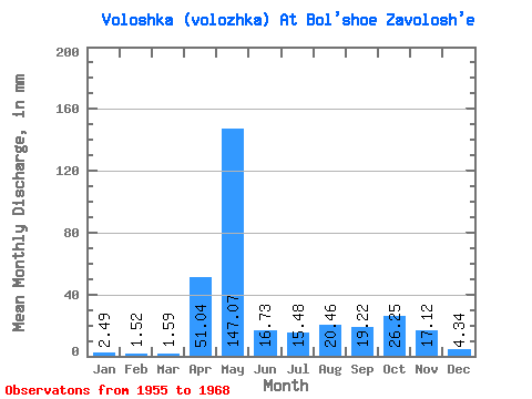
| Units: | m3/s |
| Statistic | Jan | Feb | Mar | Apr | May | Jun | Jul | Aug | Sep | Oct | Nov | Dec | Annual |
|---|---|---|---|---|---|---|---|---|---|---|---|---|---|
| Mean | 2.49 | 1.53 | 1.59 | 51.04 | 147.04 | 16.73 | 15.48 | 20.46 | 19.22 | 26.25 | 17.11 | 4.34 | 324.42 |
| Standard Deviation | 1.78 | 1.23 | 0.89 | 40.72 | 74.01 | 6.46 | 14.42 | 33.94 | 25.76 | 21.68 | 10.57 | 2.69 | 126.55 |
| Min | 0.29 | 0.19 | 0.26 | 4.28 | 53.98 | 8.27 | 3.32 | 0.64 | 0.70 | 6.84 | 3.66 | 1.06 | 180.84 |
| Max | 7.01 | 4.30 | 3.40 | 155.11 | 265.25 | 32.09 | 53.56 | 122.00 | 78.17 | 73.96 | 40.65 | 9.95 | 513.14 |
| Coefficient of Variation | 0.71 | 0.81 | 0.56 | 0.80 | 0.50 | 0.39 | 0.93 | 1.66 | 1.34 | 0.83 | 0.62 | 0.62 | 0.39 |
 Return to R-Arctic Net Home Page