|
|
|||||||||||||||||
| Point ID: 8826 | Downloads | Plots | Site Data | Code: 70024 |
|
|
|||||||||||||||||
| Download | |
|---|---|
| Site Descriptor Information | Site Time Series Data |
| Link to all available data | |
| View: | Time Series | All |
| Units: | mm |
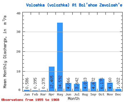
| Statistic | Jan | Feb | Mar | Apr | May | Jun | Jul | Aug | Sep | Oct | Nov | Dec | Annual |
|---|---|---|---|---|---|---|---|---|---|---|---|---|---|
| Mean | 0.59 | 0.40 | 0.38 | 12.40 | 34.59 | 4.07 | 3.64 | 4.81 | 4.67 | 6.17 | 4.16 | 1.02 | 6.48 |
| Standard Deviation | 0.42 | 0.32 | 0.21 | 9.90 | 17.41 | 1.57 | 3.39 | 7.99 | 6.26 | 5.10 | 2.57 | 0.63 | 2.53 |
| Min | 0.07 | 0.05 | 0.06 | 1.04 | 12.70 | 2.01 | 0.78 | 0.15 | 0.17 | 1.61 | 0.89 | 0.25 | 3.61 |
| Max | 1.65 | 1.11 | 0.80 | 37.70 | 62.40 | 7.80 | 12.60 | 28.70 | 19.00 | 17.40 | 9.88 | 2.34 | 10.24 |
| Coefficient of Variation | 0.71 | 0.81 | 0.56 | 0.80 | 0.50 | 0.39 | 0.93 | 1.66 | 1.34 | 0.83 | 0.62 | 0.62 | 0.39 |
 Return to R-Arctic Net Home Page