|
|
|||||||||||||||||
| Point ID: 8803 | Downloads | Plots | Site Data | Code: 12271 |
|
|
|||||||||||||||||
| Download | |
|---|---|
| Site Descriptor Information | Site Time Series Data |
| Link to all available data | |
| View: | Time Series | All |
| Units: | m3/s |
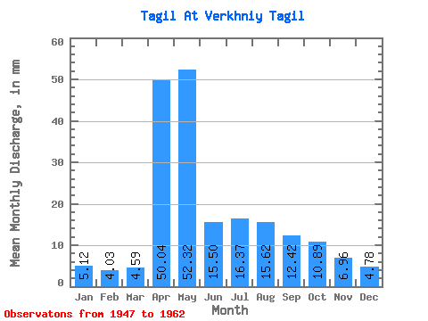
| Statistic | Jan | Feb | Mar | Apr | May | Jun | Jul | Aug | Sep | Oct | Nov | Dec | Annual |
|---|---|---|---|---|---|---|---|---|---|---|---|---|---|
| Mean | 5.11 | 4.06 | 4.58 | 50.04 | 52.31 | 15.50 | 16.36 | 15.62 | 12.41 | 10.89 | 6.96 | 4.78 | 200.00 |
| Standard Deviation | 3.35 | 2.94 | 3.27 | 24.26 | 30.76 | 11.92 | 15.94 | 17.51 | 12.71 | 8.00 | 4.25 | 3.58 | 54.20 |
| Min | 0.46 | 0.47 | 0.31 | 7.03 | 10.90 | 4.22 | 0.45 | 0.41 | 1.91 | 2.08 | 0.50 | 0.51 | 136.77 |
| Max | 10.28 | 9.08 | 10.17 | 79.77 | 94.77 | 51.94 | 51.48 | 56.57 | 48.12 | 28.96 | 15.97 | 10.59 | 302.25 |
| Coefficient of Variation | 0.66 | 0.72 | 0.71 | 0.48 | 0.59 | 0.77 | 0.97 | 1.12 | 1.02 | 0.73 | 0.61 | 0.75 | 0.27 |
 Return to R-Arctic Net Home Page