|
|
|||||||||||||||||
| Point ID: 8803 | Downloads | Plots | Site Data | Code: 12271 |
|
|
|||||||||||||||||
| Download | |
|---|---|
| Site Descriptor Information | Site Time Series Data |
| Link to all available data | |
| View: | Time Series | All |
| Units: | mm |
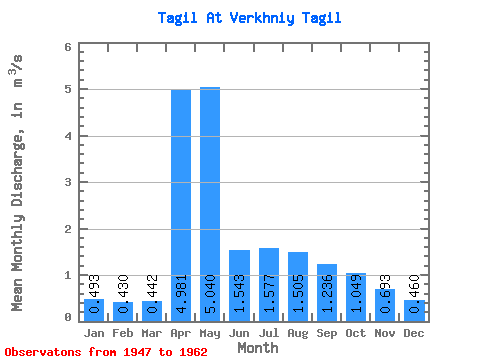
| Statistic | Jan | Feb | Mar | Apr | May | Jun | Jul | Aug | Sep | Oct | Nov | Dec | Annual |
|---|---|---|---|---|---|---|---|---|---|---|---|---|---|
| Mean | 0.49 | 0.43 | 0.44 | 4.98 | 5.04 | 1.54 | 1.58 | 1.50 | 1.24 | 1.05 | 0.69 | 0.46 | 1.64 |
| Standard Deviation | 0.32 | 0.31 | 0.32 | 2.41 | 2.96 | 1.19 | 1.54 | 1.69 | 1.27 | 0.77 | 0.42 | 0.34 | 0.44 |
| Min | 0.04 | 0.05 | 0.03 | 0.70 | 1.05 | 0.42 | 0.04 | 0.04 | 0.19 | 0.20 | 0.05 | 0.05 | 1.12 |
| Max | 0.99 | 0.96 | 0.98 | 7.94 | 9.13 | 5.17 | 4.96 | 5.45 | 4.79 | 2.79 | 1.59 | 1.02 | 2.47 |
| Coefficient of Variation | 0.66 | 0.72 | 0.71 | 0.48 | 0.59 | 0.77 | 0.97 | 1.12 | 1.02 | 0.73 | 0.61 | 0.75 | 0.27 |
 Return to R-Arctic Net Home Page