|
|
|||||||||||||||||
| Point ID: 8802 | Downloads | Plots | Site Data | Code: 12270 |
|
|
|||||||||||||||||
| Download | |
|---|---|
| Site Descriptor Information | Site Time Series Data |
| Link to all available data | |
|
|
| View: | Statistics | Time Series |
| Units: | mm |
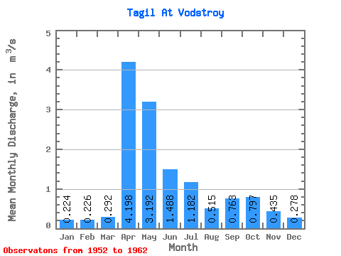
| Statistic | Jan | Feb | Mar | Apr | May | Jun | Jul | Aug | Sep | Oct | Nov | Dec | Annual |
|---|---|---|---|---|---|---|---|---|---|---|---|---|---|
| Mean | 0.22 | 0.23 | 0.29 | 4.20 | 3.19 | 1.49 | 1.18 | 0.52 | 0.76 | 0.80 | 0.43 | 0.28 | 1.12 |
| Standard Deviation | 0.05 | 0.05 | 0.15 | 2.11 | 1.88 | 1.23 | 1.14 | 0.35 | 0.54 | 0.31 | 0.23 | 0.09 | 0.36 |
| Min | 0.17 | 0.18 | 0.15 | 0.78 | 1.28 | 0.37 | 0.24 | 0.18 | 0.26 | 0.28 | 0.19 | 0.17 | 0.75 |
| Max | 0.27 | 0.28 | 0.50 | 6.05 | 5.93 | 3.52 | 3.19 | 1.15 | 1.70 | 1.08 | 0.79 | 0.38 | 1.59 |
| Coefficient of Variation | 0.21 | 0.20 | 0.50 | 0.50 | 0.59 | 0.82 | 0.97 | 0.67 | 0.71 | 0.39 | 0.54 | 0.31 | 0.32 |
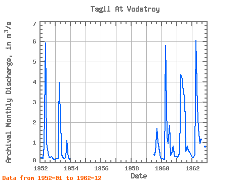
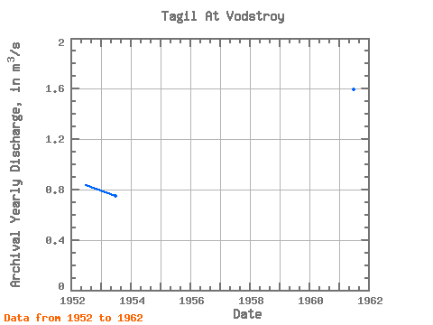
| Year | Jan | Feb | Mar | Apr | May | Jun | Jul | Aug | Sep | Oct | Nov | Dec | Annual | 1952 | 0.24 | 0.23 | 0.21 | 0.78 | 5.93 | 0.96 | 0.48 | 0.27 | 0.26 | 0.28 | 0.19 | 0.17 | 0.83 | 1953 | 0.17 | 0.18 | 0.21 | 3.98 | 1.83 | 0.37 | 0.24 | 0.18 | 0.27 | 1.08 | 0.25 | 0.20 | 0.75 | 1959 | 0.39 | 0.55 | 1.70 | 1.02 | 0.60 | 0.24 | 1960 | 0.18 | 0.18 | 0.15 | 5.82 | 1.28 | 0.93 | 1.84 | 0.37 | 0.54 | 0.81 | 0.29 | 0.32 | 1.06 | 1961 | 0.27 | 0.28 | 0.50 | 4.36 | 4.16 | 3.52 | 3.19 | 0.57 | 0.82 | 0.60 | 0.49 | 0.38 | 1.59 | 1962 | 0.26 | 0.26 | 0.39 | 6.05 | 2.76 | 1.66 | 0.95 | 1.15 | 0.99 | 0.99 | 0.79 | 0.36 | 1.38 |
|---|
 Return to R-Arctic Net Home Page