|
|
|||||||||||||||||
| Point ID: 8800 | Downloads | Plots | Site Data | Code: 12265 |
|
|
|||||||||||||||||
| Download | |
|---|---|
| Site Descriptor Information | Site Time Series Data |
| Link to all available data | |
| View: | Time Series | All |
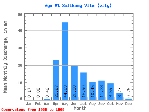
| Units: | m3/s |
| Statistic | Jan | Feb | Mar | Apr | May | Jun | Jul | Aug | Sep | Oct | Nov | Dec | Annual |
|---|---|---|---|---|---|---|---|---|---|---|---|---|---|
| Mean | 0.16 | 0.08 | 0.46 | 23.27 | 44.68 | 20.30 | 15.89 | 10.45 | 11.23 | 9.59 | 3.77 | 0.76 | 145.46 |
| Standard Deviation | 0.24 | 0.13 | 1.01 | 19.82 | 36.48 | 17.71 | 20.94 | 18.48 | 26.82 | 16.52 | 6.86 | 1.15 | 118.63 |
| Min | 0.00 | 0.00 | 0.00 | 0.00 | 3.99 | 2.54 | 0.33 | 0.05 | 0.12 | 0.15 | 0.05 | 0.00 | 25.36 |
| Max | 0.75 | 0.35 | 4.09 | 79.36 | 174.31 | 76.82 | 85.79 | 79.27 | 143.27 | 67.97 | 35.16 | 4.38 | 479.81 |
| Coefficient of Variation | 1.44 | 1.62 | 2.21 | 0.85 | 0.82 | 0.87 | 1.32 | 1.77 | 2.39 | 1.72 | 1.82 | 1.51 | 0.82 |
 Return to R-Arctic Net Home Page