|
|
|||||||||||||||||
| Point ID: 8800 | Downloads | Plots | Site Data | Code: 12265 |
|
|
|||||||||||||||||
| Download | |
|---|---|
| Site Descriptor Information | Site Time Series Data |
| Link to all available data | |
| View: | Time Series | All |
| Units: | mm |
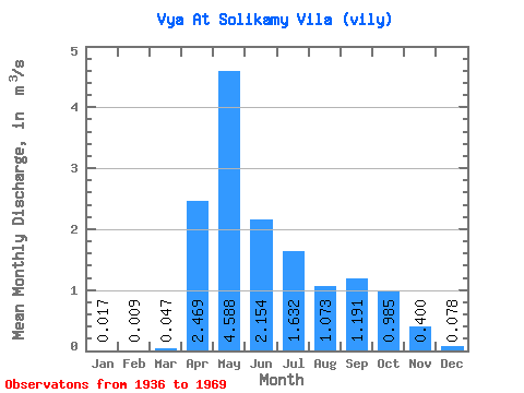
| Statistic | Jan | Feb | Mar | Apr | May | Jun | Jul | Aug | Sep | Oct | Nov | Dec | Annual |
|---|---|---|---|---|---|---|---|---|---|---|---|---|---|
| Mean | 0.02 | 0.01 | 0.05 | 2.47 | 4.59 | 2.15 | 1.63 | 1.07 | 1.19 | 0.98 | 0.40 | 0.08 | 1.27 |
| Standard Deviation | 0.02 | 0.01 | 0.10 | 2.10 | 3.75 | 1.88 | 2.15 | 1.90 | 2.84 | 1.70 | 0.73 | 0.12 | 1.03 |
| Min | 0.00 | 0.00 | 0.00 | 0.00 | 0.41 | 0.27 | 0.03 | 0.01 | 0.01 | 0.01 | 0.01 | 0.00 | 0.22 |
| Max | 0.08 | 0.04 | 0.42 | 8.42 | 17.90 | 8.15 | 8.81 | 8.14 | 15.20 | 6.98 | 3.73 | 0.45 | 4.18 |
| Coefficient of Variation | 1.44 | 1.62 | 2.21 | 0.85 | 0.82 | 0.87 | 1.32 | 1.77 | 2.39 | 1.72 | 1.82 | 1.51 | 0.82 |
 Return to R-Arctic Net Home Page