|
|
|||||||||||||||||
| Point ID: 8757 | Downloads | Plots | Site Data | Code: 12027 |
|
|
|||||||||||||||||
| Download | |
|---|---|
| Site Descriptor Information | Site Time Series Data |
| Link to all available data | |
|
|
| View: | Statistics | Time Series |
| Units: | mm |
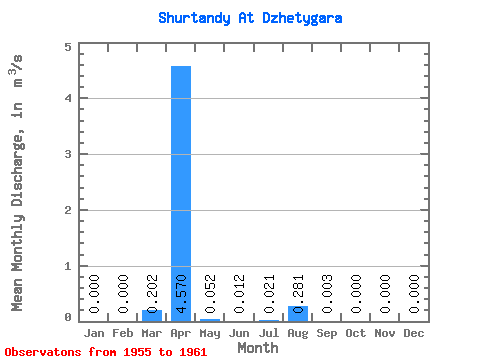
| Statistic | Jan | Feb | Mar | Apr | May | Jun | Jul | Aug | Sep | Oct | Nov | Dec | Annual |
|---|---|---|---|---|---|---|---|---|---|---|---|---|---|
| Mean | 0.00 | 0.00 | 0.20 | 4.57 | 0.05 | 0.01 | 0.02 | 0.28 | 0.00 | 0.00 | 0.00 | 0.00 | 0.37 |
| Standard Deviation | 0.00 | 0.00 | 0.45 | 1.85 | 0.04 | 0.01 | 0.03 | 0.62 | 0.01 | 0.00 | 0.00 | 0.00 | 0.20 |
| Min | 0.00 | 0.00 | 0.00 | 2.30 | 0.00 | 0.00 | 0.00 | 0.00 | 0.00 | 0.00 | 0.00 | 0.00 | 0.19 |
| Max | 0.00 | 0.00 | 1.01 | 6.55 | 0.09 | 0.03 | 0.05 | 1.40 | 0.02 | 0.00 | 0.00 | 0.00 | 0.59 |
| Coefficient of Variation | 2.24 | 0.41 | 0.72 | 1.19 | 1.37 | 2.22 | 2.24 | 0.54 |
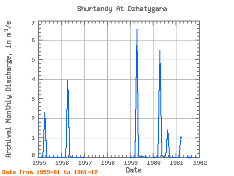
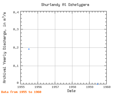
| Year | Jan | Feb | Mar | Apr | May | Jun | Jul | Aug | Sep | Oct | Nov | Dec | Annual | 1955 | 0.00 | 0.00 | 0.00 | 2.30 | 0.00 | 0.00 | 0.00 | 0.00 | 0.00 | 0.00 | 0.00 | 0.00 | 0.19 | 1956 | 0.00 | 0.00 | 0.00 | 3.96 | 0.07 | 0.00 | 0.00 | 0.00 | 0.00 | 0.00 | 0.00 | 0.00 | 0.34 | 1959 | 0.00 | 0.00 | 0.00 | 6.55 | 0.05 | 0.03 | 0.05 | 0.01 | 0.00 | 1960 | 0.00 | 0.00 | 0.00 | 5.47 | 0.09 | 0.02 | 0.05 | 1.40 | 0.02 | 0.00 | 0.00 | 0.00 | 0.59 | 1961 | 0.00 | 0.00 | 1.01 | 0.00 | 0.00 | 0.00 | 0.00 | 0.00 | 0.00 |
|---|
 Return to R-Arctic Net Home Page