|
|
|||||||||||||||||
| Point ID: 8757 | Downloads | Plots | Site Data | Code: 12027 |
|
|
|||||||||||||||||
| Download | |
|---|---|
| Site Descriptor Information | Site Time Series Data |
| Link to all available data | |
|
|
| View: | Statistics | Time Series |
| Units: | m3/s |
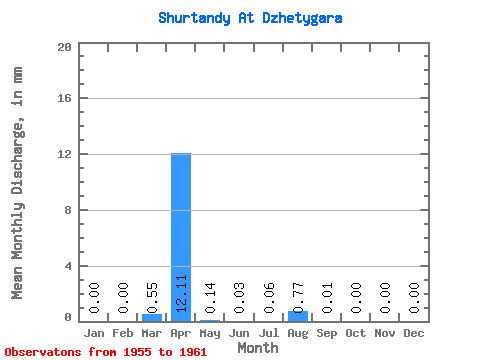
| Statistic | Jan | Feb | Mar | Apr | May | Jun | Jul | Aug | Sep | Oct | Nov | Dec | Annual |
|---|---|---|---|---|---|---|---|---|---|---|---|---|---|
| Mean | 0.00 | 0.00 | 0.55 | 12.11 | 0.14 | 0.03 | 0.06 | 0.77 | 0.01 | 0.00 | 0.00 | 0.00 | 11.99 |
| Standard Deviation | 0.00 | 0.00 | 1.24 | 4.90 | 0.10 | 0.04 | 0.08 | 1.71 | 0.02 | 0.00 | 0.00 | 0.00 | 6.46 |
| Min | 0.00 | 0.00 | 0.00 | 6.10 | 0.00 | 0.00 | 0.00 | 0.00 | 0.00 | 0.00 | 0.00 | 0.00 | 6.18 |
| Max | 0.00 | 0.00 | 2.77 | 17.36 | 0.24 | 0.07 | 0.15 | 3.83 | 0.04 | 0.00 | 0.00 | 0.00 | 18.95 |
| Coefficient of Variation | 2.24 | 0.41 | 0.72 | 1.19 | 1.37 | 2.22 | 2.24 | 0.54 |
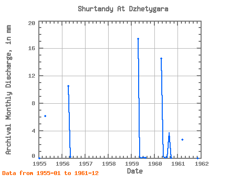
| Year | Jan | Feb | Mar | Apr | May | Jun | Jul | Aug | Sep | Oct | Nov | Dec | Annual | 1955 | 0.00 | 0.00 | 0.00 | 6.10 | 0.00 | 0.00 | 0.00 | 0.00 | 0.00 | 0.00 | 0.00 | 0.00 | 6.18 | 1956 | 0.00 | 0.00 | 0.00 | 10.49 | 0.18 | 0.00 | 0.00 | 0.00 | 0.00 | 0.00 | 0.00 | 0.00 | 10.83 | 1959 | 0.00 | 0.00 | 0.00 | 17.36 | 0.15 | 0.07 | 0.13 | 0.02 | 0.00 | 1960 | 0.00 | 0.00 | 0.00 | 14.50 | 0.24 | 0.05 | 0.15 | 3.83 | 0.04 | 0.00 | 0.00 | 0.00 | 18.95 | 1961 | 0.00 | 0.00 | 2.77 | 0.00 | 0.00 | 0.00 | 0.00 | 0.00 | 0.00 |
|---|
 Return to R-Arctic Net Home Page