|
|
|||||||||||||||||
| Point ID: 8745 | Downloads | Plots | Site Data | Code: 12631 |
|
|
|||||||||||||||||
| Download | |
|---|---|
| Site Descriptor Information | Site Time Series Data |
| Link to all available data | |
|
|
| View: | Statistics | Time Series |
| Units: | mm |
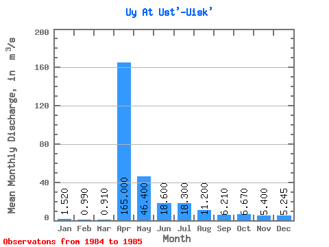
| Statistic | Jan | Feb | Mar | Apr | May | Jun | Jul | Aug | Sep | Oct | Nov | Dec | Annual |
|---|---|---|---|---|---|---|---|---|---|---|---|---|---|
| Mean | 1.52 | 0.99 | 0.91 | 165.00 | 46.40 | 18.60 | 18.30 | 11.20 | 6.21 | 6.67 | 5.40 | 5.25 | 23.80 |
| Standard Deviation | 1.27 | ||||||||||||
| Min | 1.52 | 0.99 | 0.91 | 165.00 | 46.40 | 18.60 | 18.30 | 11.20 | 6.21 | 6.67 | 5.40 | 4.35 | 23.80 |
| Max | 1.52 | 0.99 | 0.91 | 165.00 | 46.40 | 18.60 | 18.30 | 11.20 | 6.21 | 6.67 | 5.40 | 6.14 | 23.80 |
| Coefficient of Variation | 0.24 |
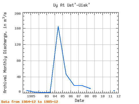
| Year | Jan | Feb | Mar | Apr | May | Jun | Jul | Aug | Sep | Oct | Nov | Dec | Annual | 1984 | 6.14 | 1985 | 1.52 | 0.99 | 0.91 | 165.00 | 46.40 | 18.60 | 18.30 | 11.20 | 6.21 | 6.67 | 5.40 | 4.35 | 23.80 |
|---|
 Return to R-Arctic Net Home Page