|
|
|||||||||||||||||
| Point ID: 8736 | Downloads | Plots | Site Data | Code: 12621 |
|
|
|||||||||||||||||
| Download | |
|---|---|
| Site Descriptor Information | Site Time Series Data |
| Link to all available data | |
|
|
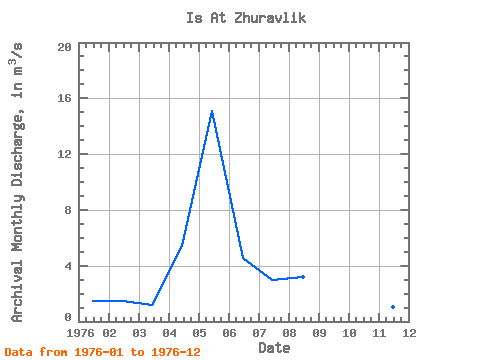
| View: | Statistics | Time Series |
| Units: | mm |
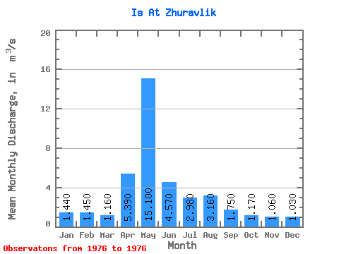
| Statistic | Jan | Feb | Mar | Apr | May | Jun | Jul | Aug | Sep | Oct | Nov | Dec | Annual |
|---|---|---|---|---|---|---|---|---|---|---|---|---|---|
| Mean | 1.44 | 1.45 | 1.16 | 5.39 | 15.10 | 4.57 | 2.98 | 3.16 | 1.75 | 1.17 | 1.06 | 1.03 | 3.35 |
| Standard Deviation | |||||||||||||
| Min | 1.44 | 1.45 | 1.16 | 5.39 | 15.10 | 4.57 | 2.98 | 3.16 | 1.75 | 1.17 | 1.06 | 1.03 | 3.35 |
| Max | 1.44 | 1.45 | 1.16 | 5.39 | 15.10 | 4.57 | 2.98 | 3.16 | 1.75 | 1.17 | 1.06 | 1.03 | 3.35 |
| Coefficient of Variation |
| Year | Jan | Feb | Mar | Apr | May | Jun | Jul | Aug | Sep | Oct | Nov | Dec | Annual | 1976 | 1.44 | 1.45 | 1.16 | 5.39 | 15.10 | 4.57 | 2.98 | 3.16 | 1.75 | 1.17 | 1.06 | 1.03 | 3.35 |
|---|
 Return to R-Arctic Net Home Page