|
|
|||||||||||||||||
| Point ID: 8736 | Downloads | Plots | Site Data | Code: 12621 |
|
|
|||||||||||||||||
| Download | |
|---|---|
| Site Descriptor Information | Site Time Series Data |
| Link to all available data | |
|
|
| View: | Statistics | Time Series |
| Units: | m3/s |
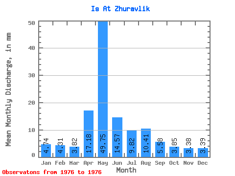
| Statistic | Jan | Feb | Mar | Apr | May | Jun | Jul | Aug | Sep | Oct | Nov | Dec | Annual |
|---|---|---|---|---|---|---|---|---|---|---|---|---|---|
| Mean | 4.74 | 4.35 | 3.82 | 17.18 | 49.74 | 14.57 | 9.82 | 10.41 | 5.58 | 3.85 | 3.38 | 3.39 | 130.24 |
| Standard Deviation | |||||||||||||
| Min | 4.74 | 4.35 | 3.82 | 17.18 | 49.74 | 14.57 | 9.82 | 10.41 | 5.58 | 3.85 | 3.38 | 3.39 | 130.24 |
| Max | 4.74 | 4.35 | 3.82 | 17.18 | 49.74 | 14.57 | 9.82 | 10.41 | 5.58 | 3.85 | 3.38 | 3.39 | 130.24 |
| Coefficient of Variation |
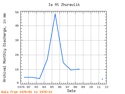
| Year | Jan | Feb | Mar | Apr | May | Jun | Jul | Aug | Sep | Oct | Nov | Dec | Annual | 1976 | 4.74 | 4.35 | 3.82 | 17.18 | 49.74 | 14.57 | 9.82 | 10.41 | 5.58 | 3.85 | 3.38 | 3.39 | 130.24 |
|---|
 Return to R-Arctic Net Home Page