|
|
|||||||||||||||||
| Point ID: 8704 | Downloads | Plots | Site Data | Code: 11662 |
|
|
|||||||||||||||||
| Download | |
|---|---|
| Site Descriptor Information | Site Time Series Data |
| Link to all available data | |
| View: | Time Series | All |
| Units: | m3/s |
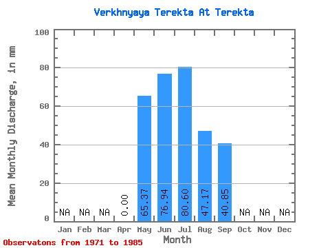
| Statistic | Jan | Feb | Mar | Apr | May | Jun | Jul | Aug | Sep | Oct | Nov | Dec | Annual |
|---|---|---|---|---|---|---|---|---|---|---|---|---|---|
| Mean | 0.00 | 65.36 | 76.93 | 80.57 | 47.15 | 40.86 | |||||||
| Standard Deviation | 0.00 | 48.56 | 66.00 | 87.74 | 40.40 | 31.52 | |||||||
| Min | 0.00 | 23.80 | 25.44 | 23.31 | 4.46 | 14.40 | |||||||
| Max | 0.00 | 217.22 | 242.88 | 342.19 | 133.90 | 125.28 | |||||||
| Coefficient of Variation | 0.74 | 0.86 | 1.09 | 0.86 | 0.77 |
 Return to R-Arctic Net Home Page