|
|
|||||||||||||||||
| Point ID: 8704 | Downloads | Plots | Site Data | Code: 11662 |
|
|
|||||||||||||||||
| Download | |
|---|---|
| Site Descriptor Information | Site Time Series Data |
| Link to all available data | |
| View: | Time Series | All |
| Units: | mm |
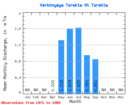
| Statistic | Jan | Feb | Mar | Apr | May | Jun | Jul | Aug | Sep | Oct | Nov | Dec | Annual |
|---|---|---|---|---|---|---|---|---|---|---|---|---|---|
| Mean | 0.00 | 1.32 | 1.60 | 1.62 | 0.95 | 0.85 | |||||||
| Standard Deviation | 0.00 | 0.98 | 1.38 | 1.77 | 0.81 | 0.66 | |||||||
| Min | 0.00 | 0.48 | 0.53 | 0.47 | 0.09 | 0.30 | |||||||
| Max | 0.00 | 4.38 | 5.06 | 6.90 | 2.70 | 2.61 | |||||||
| Coefficient of Variation | 0.74 | 0.86 | 1.09 | 0.86 | 0.77 |
 Return to R-Arctic Net Home Page