|
|
|||||||||||||||||
| Point ID: 8697 | Downloads | Plots | Site Data | Code: 11625 |
|
|
|||||||||||||||||
| Download | |
|---|---|
| Site Descriptor Information | Site Time Series Data |
| Link to all available data | |
|
|
| View: | Statistics | Time Series |
| Units: | mm |
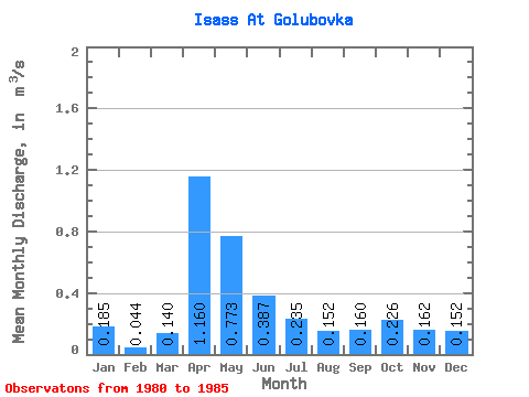
| Statistic | Jan | Feb | Mar | Apr | May | Jun | Jul | Aug | Sep | Oct | Nov | Dec | Annual |
|---|---|---|---|---|---|---|---|---|---|---|---|---|---|
| Mean | 0.18 | 0.04 | 0.14 | 1.16 | 0.77 | 0.39 | 0.23 | 0.15 | 0.16 | 0.23 | 0.16 | 0.15 | 0.29 |
| Standard Deviation | 0.01 | 0.07 | 0.38 | 0.07 | 0.06 | 0.07 | 0.12 | 0.16 | 0.12 | 0.10 | |||
| Min | 0.18 | 0.00 | 0.14 | 1.16 | 0.53 | 0.34 | 0.17 | 0.08 | 0.00 | 0.00 | 0.00 | 0.00 | 0.29 |
| Max | 0.19 | 0.13 | 0.14 | 1.16 | 1.21 | 0.47 | 0.32 | 0.21 | 0.29 | 0.39 | 0.29 | 0.22 | 0.29 |
| Coefficient of Variation | 0.04 | 1.67 | 0.49 | 0.19 | 0.27 | 0.45 | 0.78 | 0.70 | 0.77 | 0.68 |
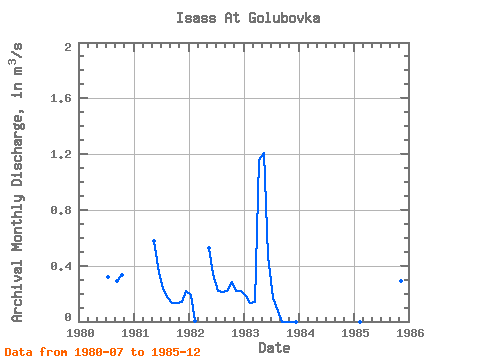
| Year | Jan | Feb | Mar | Apr | May | Jun | Jul | Aug | Sep | Oct | Nov | Dec | Annual | 1980 | 0.32 | 0.29 | 0.33 | 1981 | 0.58 | 0.35 | 0.23 | 0.17 | 0.13 | 0.13 | 0.14 | 0.22 | 1982 | 0.19 | 0.00 | 0.53 | 0.34 | 0.22 | 0.21 | 0.22 | 0.28 | 0.22 | 0.22 | 1983 | 0.18 | 0.13 | 0.14 | 1.16 | 1.21 | 0.47 | 0.17 | 0.08 | 0.00 | 0.00 | 0.00 | 0.00 | 0.29 | 1985 | 0.00 | 0.39 | 0.29 | 0.17 |
|---|
 Return to R-Arctic Net Home Page