|
|
|||||||||||||||||
| Point ID: 8697 | Downloads | Plots | Site Data | Code: 11625 |
|
|
|||||||||||||||||
| Download | |
|---|---|
| Site Descriptor Information | Site Time Series Data |
| Link to all available data | |
|
|
| View: | Statistics | Time Series |
| Units: | m3/s |
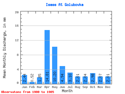
| Statistic | Jan | Feb | Mar | Apr | May | Jun | Jul | Aug | Sep | Oct | Nov | Dec | Annual |
|---|---|---|---|---|---|---|---|---|---|---|---|---|---|
| Mean | 2.44 | 0.53 | 1.85 | 14.81 | 10.20 | 4.94 | 3.10 | 2.00 | 2.04 | 2.98 | 2.08 | 2.01 | 45.81 |
| Standard Deviation | 0.09 | 0.89 | 5.00 | 0.92 | 0.82 | 0.91 | 1.60 | 2.10 | 1.59 | 1.38 | |||
| Min | 2.38 | 0.00 | 1.85 | 14.81 | 6.99 | 4.34 | 2.24 | 1.00 | 0.00 | 0.00 | 0.00 | 0.00 | 45.81 |
| Max | 2.51 | 1.56 | 1.85 | 14.81 | 15.96 | 6.00 | 4.22 | 2.77 | 3.70 | 5.14 | 3.70 | 2.90 | 45.81 |
| Coefficient of Variation | 0.04 | 1.67 | 0.49 | 0.19 | 0.27 | 0.45 | 0.78 | 0.70 | 0.77 | 0.68 |
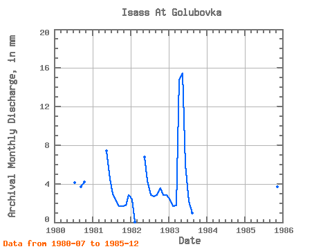
| Year | Jan | Feb | Mar | Apr | May | Jun | Jul | Aug | Sep | Oct | Nov | Dec | Annual | 1980 | 4.22 | 3.70 | 4.35 | 1981 | 7.65 | 4.47 | 3.03 | 2.24 | 1.66 | 1.71 | 1.79 | 2.90 | 1982 | 2.51 | 0.04 | 6.99 | 4.34 | 2.90 | 2.77 | 2.81 | 3.69 | 2.81 | 2.90 | 1983 | 2.38 | 1.56 | 1.85 | 14.81 | 15.96 | 6.00 | 2.24 | 1.00 | 0.00 | 0.00 | 0.00 | 0.00 | 45.81 | 1985 | 0.00 | 5.14 | 3.70 | 2.24 |
|---|
 Return to R-Arctic Net Home Page