|
|
|||||||||||||||||
| Point ID: 8648 | Downloads | Plots | Site Data | Code: 11401 |
|
|
|||||||||||||||||
| Download | |
|---|---|
| Site Descriptor Information | Site Time Series Data |
| Link to all available data | |
|
|
| View: | Statistics | Time Series |
| Units: | mm |
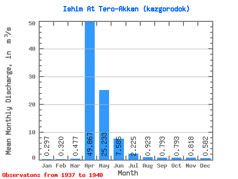
| Statistic | Jan | Feb | Mar | Apr | May | Jun | Jul | Aug | Sep | Oct | Nov | Dec | Annual |
|---|---|---|---|---|---|---|---|---|---|---|---|---|---|
| Mean | 0.30 | 0.32 | 0.48 | 49.87 | 25.23 | 7.58 | 2.23 | 0.92 | 0.79 | 0.79 | 0.82 | 0.58 | 7.16 |
| Standard Deviation | 0.11 | 0.24 | 0.31 | 60.24 | 20.16 | 7.51 | 1.61 | 0.40 | 0.23 | 0.22 | 0.22 | 0.21 | 7.07 |
| Min | 0.20 | 0.17 | 0.14 | 8.60 | 13.10 | 1.97 | 0.53 | 0.43 | 0.60 | 0.62 | 0.66 | 0.38 | 2.39 |
| Max | 0.41 | 0.60 | 0.75 | 119.00 | 48.50 | 18.20 | 3.83 | 1.33 | 1.10 | 1.10 | 1.13 | 0.85 | 15.29 |
| Coefficient of Variation | 0.36 | 0.76 | 0.65 | 1.21 | 0.80 | 0.99 | 0.72 | 0.43 | 0.30 | 0.28 | 0.26 | 0.36 | 0.99 |
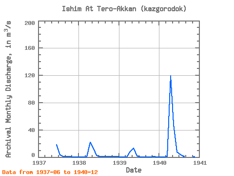
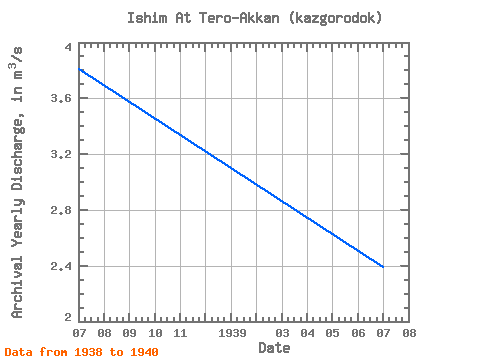
| Year | Jan | Feb | Mar | Apr | May | Jun | Jul | Aug | Sep | Oct | Nov | Dec | Annual | 1937 | 18.20 | 3.35 | 1.33 | 0.85 | 0.81 | 0.69 | 0.38 | 1938 | 0.20 | 0.17 | 0.14 | 22.00 | 14.10 | 2.58 | 1.19 | 1.14 | 1.10 | 1.10 | 1.13 | 0.85 | 3.81 | 1939 | 0.41 | 0.60 | 0.54 | 8.60 | 13.10 | 1.97 | 0.53 | 0.43 | 0.62 | 0.64 | 0.79 | 0.45 | 2.39 | 1940 | 0.28 | 0.19 | 0.75 | 119.00 | 48.50 | 7.59 | 3.83 | 0.79 | 0.60 | 0.62 | 0.66 | 0.65 | 15.29 |
|---|
 Return to R-Arctic Net Home Page