|
|
|||||||||||||||||
| Point ID: 8648 | Downloads | Plots | Site Data | Code: 11401 |
|
|
|||||||||||||||||
| Download | |
|---|---|
| Site Descriptor Information | Site Time Series Data |
| Link to all available data | |

|
|
| View: | Statistics | Time Series |
| Units: | m3/s |
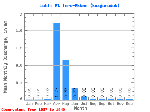
| Statistic | Jan | Feb | Mar | Apr | May | Jun | Jul | Aug | Sep | Oct | Nov | Dec | Annual |
|---|---|---|---|---|---|---|---|---|---|---|---|---|---|
| Mean | 0.01 | 0.01 | 0.02 | 1.77 | 0.93 | 0.27 | 0.08 | 0.03 | 0.03 | 0.03 | 0.03 | 0.02 | 3.10 |
| Standard Deviation | 0.00 | 0.01 | 0.01 | 2.14 | 0.74 | 0.27 | 0.06 | 0.01 | 0.01 | 0.01 | 0.01 | 0.01 | 3.06 |
| Min | 0.01 | 0.01 | 0.01 | 0.30 | 0.48 | 0.07 | 0.02 | 0.02 | 0.02 | 0.02 | 0.02 | 0.01 | 1.03 |
| Max | 0.01 | 0.02 | 0.03 | 4.22 | 1.78 | 0.65 | 0.14 | 0.05 | 0.04 | 0.04 | 0.04 | 0.03 | 6.61 |
| Coefficient of Variation | 0.36 | 0.76 | 0.65 | 1.21 | 0.80 | 0.99 | 0.72 | 0.43 | 0.30 | 0.28 | 0.26 | 0.36 | 0.99 |
| Year | Jan | Feb | Mar | Apr | May | Jun | Jul | Aug | Sep | Oct | Nov | Dec | Annual | 1937 | 0.65 | 0.12 | 0.05 | 0.03 | 0.03 | 0.02 | 0.01 | 1938 | 0.01 | 0.01 | 0.01 | 0.78 | 0.52 | 0.09 | 0.04 | 0.04 | 0.04 | 0.04 | 0.04 | 0.03 | 1.65 | 1939 | 0.01 | 0.02 | 0.02 | 0.30 | 0.48 | 0.07 | 0.02 | 0.02 | 0.02 | 0.02 | 0.03 | 0.02 | 1.03 | 1940 | 0.01 | 0.01 | 0.03 | 4.22 | 1.78 | 0.27 | 0.14 | 0.03 | 0.02 | 0.02 | 0.02 | 0.02 | 6.61 |
|---|
 Return to R-Arctic Net Home Page