|
|
|||||||||||||||||
| Point ID: 8616 | Downloads | Plots | Site Data | Code: 11239 |
|
|
|||||||||||||||||
| Download | |
|---|---|
| Site Descriptor Information | Site Time Series Data |
| Link to all available data | |
|
|
| View: | Statistics | Time Series |
| Units: | mm |
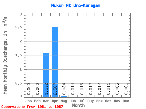
| Statistic | Jan | Feb | Mar | Apr | May | Jun | Jul | Aug | Sep | Oct | Nov | Dec | Annual |
|---|---|---|---|---|---|---|---|---|---|---|---|---|---|
| Mean | 0.00 | 0.00 | 1.57 | 2.51 | 0.03 | 0.01 | 0.02 | 0.01 | 0.01 | 0.01 | 0.01 | 0.00 | 0.55 |
| Standard Deviation | 0.00 | 0.00 | 2.23 | 3.77 | 0.04 | 0.01 | 0.01 | 0.01 | 0.01 | 0.01 | 0.01 | 0.00 | 0.60 |
| Min | 0.00 | 0.00 | 0.00 | 0.04 | 0.00 | 0.00 | 0.00 | 0.00 | 0.00 | 0.00 | 0.00 | 0.00 | 0.02 |
| Max | 0.00 | 0.00 | 5.14 | 9.05 | 0.10 | 0.03 | 0.03 | 0.03 | 0.03 | 0.02 | 0.01 | 0.00 | 1.20 |
| Coefficient of Variation | 1.42 | 1.50 | 1.13 | 0.76 | 0.82 | 0.87 | 0.87 | 0.89 | 0.77 | 2.24 | 1.10 |
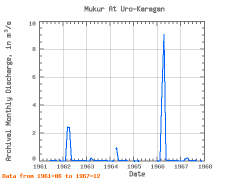
| Year | Jan | Feb | Mar | Apr | May | Jun | Jul | Aug | Sep | Oct | Nov | Dec | Annual | 1961 | 0.01 | 0.01 | 0.01 | 0.01 | 0.01 | 0.00 | 1962 | 0.00 | 0.00 | 2.41 | 2.37 | 0.04 | 0.02 | 0.03 | 0.03 | 0.03 | 0.02 | 0.01 | 0.00 | 0.41 | 1963 | 0.00 | 0.00 | 0.20 | 0.04 | 0.00 | 0.00 | 0.00 | 0.00 | 0.00 | 0.00 | 0.00 | 0.00 | 0.02 | 1964 | 0.00 | 0.00 | 0.86 | 0.02 | 0.02 | 0.03 | 0.02 | 0.02 | 1965 | 0.00 | 0.00 | 0.00 | 1966 | 0.00 | 0.00 | 5.14 | 9.05 | 0.10 | 0.03 | 0.02 | 0.02 | 0.02 | 0.02 | 0.00 | 0.00 | 1.20 | 1967 | 0.00 | 0.00 | 0.11 | 0.21 | 0.01 | 0.00 | 0.00 | 0.00 | 0.00 | 0.00 | 0.00 |
|---|
 Return to R-Arctic Net Home Page