|
|
|||||||||||||||||
| Point ID: 8616 | Downloads | Plots | Site Data | Code: 11239 |
|
|
|||||||||||||||||
| Download | |
|---|---|
| Site Descriptor Information | Site Time Series Data |
| Link to all available data | |
|
|
| View: | Statistics | Time Series |
| Units: | m3/s |
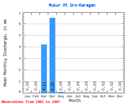
| Statistic | Jan | Feb | Mar | Apr | May | Jun | Jul | Aug | Sep | Oct | Nov | Dec | Annual |
|---|---|---|---|---|---|---|---|---|---|---|---|---|---|
| Mean | 0.00 | 0.00 | 4.21 | 6.50 | 0.09 | 0.04 | 0.04 | 0.03 | 0.03 | 0.03 | 0.02 | 0.00 | 17.19 |
| Standard Deviation | 0.00 | 0.00 | 5.98 | 9.77 | 0.10 | 0.03 | 0.03 | 0.03 | 0.03 | 0.03 | 0.01 | 0.00 | 18.92 |
| Min | 0.00 | 0.00 | 0.00 | 0.12 | 0.01 | 0.00 | 0.01 | 0.01 | 0.01 | 0.01 | 0.01 | 0.00 | 0.69 |
| Max | 0.00 | 0.00 | 13.77 | 23.46 | 0.26 | 0.08 | 0.09 | 0.07 | 0.07 | 0.06 | 0.03 | 0.01 | 37.84 |
| Coefficient of Variation | 1.42 | 1.50 | 1.13 | 0.76 | 0.82 | 0.87 | 0.87 | 0.89 | 0.77 | 2.24 | 1.10 |
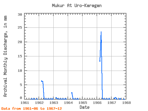
| Year | Jan | Feb | Mar | Apr | May | Jun | Jul | Aug | Sep | Oct | Nov | Dec | Annual | 1961 | 0.04 | 0.04 | 0.02 | 0.02 | 0.02 | 0.00 | 1962 | 0.00 | 0.00 | 6.46 | 6.14 | 0.10 | 0.05 | 0.07 | 0.07 | 0.07 | 0.06 | 0.03 | 0.01 | 13.04 | 1963 | 0.00 | 0.00 | 0.54 | 0.12 | 0.01 | 0.01 | 0.01 | 0.01 | 0.01 | 0.01 | 0.01 | 0.00 | 0.69 | 1964 | 0.00 | 0.00 | 2.23 | 0.05 | 0.04 | 0.09 | 0.06 | 0.04 | 1965 | 0.00 | 0.00 | 0.00 | 1966 | 0.00 | 0.00 | 13.77 | 23.46 | 0.26 | 0.08 | 0.04 | 0.04 | 0.05 | 0.05 | 0.01 | 0.00 | 37.84 | 1967 | 0.00 | 0.00 | 0.29 | 0.54 | 0.03 | 0.00 | 0.01 | 0.01 | 0.01 | 0.01 | 0.00 |
|---|
 Return to R-Arctic Net Home Page