|
|
|||||||||||||||||
| Point ID: 8598 | Downloads | Plots | Site Data | Code: 11200 |
|
|
|||||||||||||||||
| Download | |
|---|---|
| Site Descriptor Information | Site Time Series Data |
| Link to all available data | |
|
|
| View: | Statistics | Time Series |
| Units: | mm |
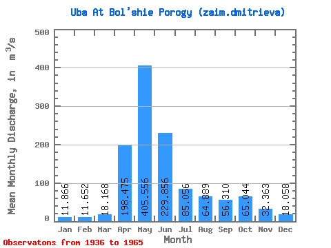
| Statistic | Jan | Feb | Mar | Apr | May | Jun | Jul | Aug | Sep | Oct | Nov | Dec | Annual |
|---|---|---|---|---|---|---|---|---|---|---|---|---|---|
| Mean | 11.87 | 11.65 | 18.17 | 198.47 | 405.56 | 229.86 | 85.06 | 64.89 | 56.31 | 65.04 | 32.36 | 18.06 | 104.51 |
| Standard Deviation | 6.07 | 6.37 | 8.40 | 105.99 | 110.12 | 119.97 | 52.46 | 40.29 | 33.13 | 28.42 | 12.94 | 7.20 | 22.00 |
| Min | 0.88 | 0.70 | 8.61 | 55.50 | 302.00 | 89.70 | 25.10 | 16.20 | 15.10 | 28.20 | 15.50 | 4.06 | 75.82 |
| Max | 19.60 | 23.40 | 30.00 | 352.00 | 664.00 | 446.00 | 190.00 | 130.00 | 112.00 | 105.00 | 54.20 | 28.60 | 141.48 |
| Coefficient of Variation | 0.51 | 0.55 | 0.46 | 0.53 | 0.27 | 0.52 | 0.62 | 0.62 | 0.59 | 0.44 | 0.40 | 0.40 | 0.21 |
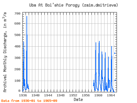
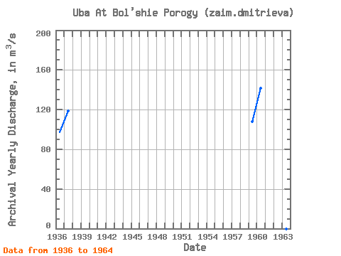
| Year | Jan | Feb | Mar | Apr | May | Jun | Jul | Aug | Sep | Oct | Nov | Dec | Annual | 1936 | 9.56 | 8.98 | 8.93 | 93.30 | 440.00 | 305.00 | 62.30 | 51.80 | 112.00 | 32.40 | 23.00 | 20.90 | 97.35 | 1937 | 19.60 | 23.40 | 21.90 | 55.50 | 664.00 | 341.00 | 109.00 | 33.00 | 34.00 | 63.00 | 34.50 | 28.60 | 118.96 | 1958 | 56.90 | 105.00 | 54.20 | 19.50 | 1959 | 19.40 | 15.00 | 11.50 | 300.00 | 433.00 | 242.00 | 98.50 | 63.20 | 31.30 | 34.30 | 27.20 | 17.90 | 107.78 | 1960 | 13.60 | 14.80 | 15.10 | 259.00 | 418.00 | 446.00 | 190.00 | 130.00 | 71.80 | 68.50 | 47.80 | 23.20 | 141.48 | 1961 | 16.40 | 9.06 | 30.00 | 352.00 | 302.00 | 117.00 | 131.00 | 112.00 | 87.60 | 74.40 | 31.60 | 16.20 | 106.61 | 1962 | 10.90 | 13.50 | 21.10 | 241.00 | 346.00 | 101.00 | 25.10 | 16.20 | 15.10 | 80.70 | 25.10 | 14.10 | 75.82 | 1963 | 7.38 | 12.90 | 28.20 | 114.00 | 308.00 | 194.00 | 40.00 | 36.40 | 38.00 | 98.90 | 1964 | 9.07 | 6.53 | 8.61 | 173.00 | 399.00 | 233.00 | 63.80 | 38.40 | 23.60 | 28.20 | 15.50 | 4.06 | 83.56 | 1965 | 0.88 | 0.70 | 340.00 | 89.70 | 45.80 | 103.00 | 92.80 |
|---|
 Return to R-Arctic Net Home Page