|
|
|||||||||||||||||
| Point ID: 8598 | Downloads | Plots | Site Data | Code: 11200 |
|
|
|||||||||||||||||
| Download | |
|---|---|
| Site Descriptor Information | Site Time Series Data |
| Link to all available data | |
|
|
| View: | Statistics | Time Series |
| Units: | m3/s |
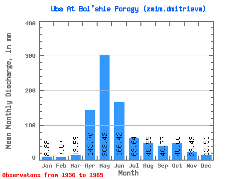
| Statistic | Jan | Feb | Mar | Apr | May | Jun | Jul | Aug | Sep | Oct | Nov | Dec | Annual |
|---|---|---|---|---|---|---|---|---|---|---|---|---|---|
| Mean | 8.88 | 7.94 | 13.59 | 143.70 | 303.37 | 166.42 | 63.62 | 48.54 | 40.77 | 48.66 | 23.43 | 13.51 | 921.30 |
| Standard Deviation | 4.54 | 4.34 | 6.28 | 76.74 | 82.38 | 86.86 | 39.24 | 30.14 | 23.99 | 21.26 | 9.37 | 5.38 | 193.95 |
| Min | 0.66 | 0.48 | 6.44 | 40.18 | 225.91 | 64.94 | 18.78 | 12.12 | 10.93 | 21.09 | 11.22 | 3.04 | 668.37 |
| Max | 14.66 | 15.95 | 22.44 | 254.86 | 496.70 | 322.91 | 142.13 | 97.25 | 81.09 | 78.55 | 39.24 | 21.39 | 1247.27 |
| Coefficient of Variation | 0.51 | 0.55 | 0.46 | 0.53 | 0.27 | 0.52 | 0.62 | 0.62 | 0.59 | 0.44 | 0.40 | 0.40 | 0.21 |
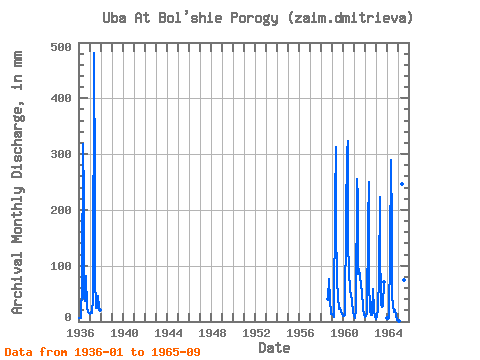
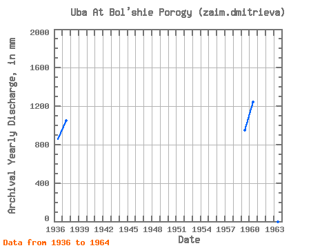
| Year | Jan | Feb | Mar | Apr | May | Jun | Jul | Aug | Sep | Oct | Nov | Dec | Annual | 1936 | 7.15 | 6.12 | 6.68 | 67.55 | 329.14 | 220.83 | 46.60 | 38.75 | 81.09 | 24.24 | 16.65 | 15.63 | 858.18 | 1937 | 14.66 | 15.95 | 16.38 | 40.18 | 496.70 | 246.89 | 81.54 | 24.68 | 24.62 | 47.13 | 24.98 | 21.39 | 1048.69 | 1958 | 41.20 | 78.55 | 39.24 | 14.59 | 1959 | 14.51 | 10.22 | 8.60 | 217.21 | 323.90 | 175.21 | 73.68 | 47.28 | 22.66 | 25.66 | 19.69 | 13.39 | 950.11 | 1960 | 10.17 | 10.09 | 11.29 | 187.52 | 312.68 | 322.91 | 142.13 | 97.25 | 51.98 | 51.24 | 34.61 | 17.36 | 1247.27 | 1961 | 12.27 | 6.17 | 22.44 | 254.86 | 225.91 | 84.71 | 97.99 | 83.78 | 63.42 | 55.66 | 22.88 | 12.12 | 939.79 | 1962 | 8.15 | 9.20 | 15.78 | 174.49 | 258.82 | 73.13 | 18.78 | 12.12 | 10.93 | 60.37 | 18.17 | 10.55 | 668.37 | 1963 | 5.52 | 8.79 | 21.09 | 82.54 | 230.40 | 140.46 | 29.92 | 27.23 | 27.51 | 73.98 | 1964 | 6.79 | 4.45 | 6.44 | 125.26 | 298.47 | 168.70 | 47.73 | 28.73 | 17.09 | 21.09 | 11.22 | 3.04 | 736.67 | 1965 | 0.66 | 0.48 | 254.34 | 64.94 | 34.26 | 77.05 | 67.19 |
|---|
 Return to R-Arctic Net Home Page