|
|
|||||||||||||||||
| Point ID: 8582 | Downloads | Plots | Site Data | Code: 11161 |
|
|
|||||||||||||||||
| Download | |
|---|---|
| Site Descriptor Information | Site Time Series Data |
| Link to all available data | |
| View: | Time Series | All |
| Units: | m3/s |
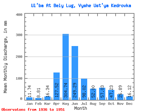
| Statistic | Jan | Feb | Mar | Apr | May | Jun | Jul | Aug | Sep | Oct | Nov | Dec | Annual |
|---|---|---|---|---|---|---|---|---|---|---|---|---|---|
| Mean | 11.74 | 8.89 | 16.33 | 127.52 | 304.70 | 249.29 | 98.00 | 51.99 | 57.02 | 47.23 | 26.89 | 16.12 | 986.54 |
| Standard Deviation | 2.19 | 2.00 | 6.61 | 38.40 | 81.45 | 107.48 | 43.41 | 28.28 | 52.74 | 26.48 | 8.64 | 3.20 | 282.07 |
| Min | 8.54 | 6.27 | 10.21 | 64.80 | 186.98 | 49.76 | 25.34 | 14.06 | 11.53 | 23.24 | 15.37 | 11.98 | 452.36 |
| Max | 15.04 | 12.83 | 32.52 | 189.54 | 528.43 | 432.77 | 176.46 | 123.14 | 238.37 | 119.31 | 45.59 | 23.43 | 1570.93 |
| Coefficient of Variation | 0.19 | 0.23 | 0.41 | 0.30 | 0.27 | 0.43 | 0.44 | 0.54 | 0.93 | 0.56 | 0.32 | 0.20 | 0.29 |
 Return to R-Arctic Net Home Page