|
|
|||||||||||||||||
| Point ID: 8582 | Downloads | Plots | Site Data | Code: 11161 |
|
|
|||||||||||||||||
| Download | |
|---|---|
| Site Descriptor Information | Site Time Series Data |
| Link to all available data | |
| View: | Time Series | All |
| Units: | mm |
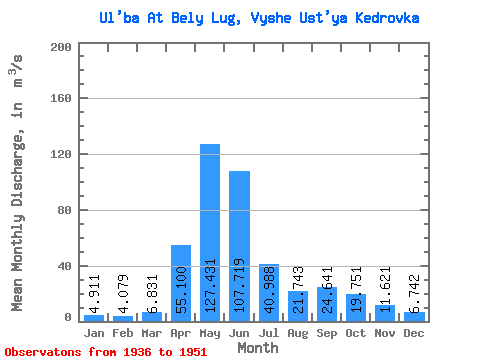
| Statistic | Jan | Feb | Mar | Apr | May | Jun | Jul | Aug | Sep | Oct | Nov | Dec | Annual |
|---|---|---|---|---|---|---|---|---|---|---|---|---|---|
| Mean | 4.91 | 4.08 | 6.83 | 55.10 | 127.43 | 107.72 | 40.99 | 21.74 | 24.64 | 19.75 | 11.62 | 6.74 | 35.01 |
| Standard Deviation | 0.92 | 0.92 | 2.77 | 16.59 | 34.06 | 46.44 | 18.16 | 11.83 | 22.79 | 11.08 | 3.73 | 1.34 | 10.01 |
| Min | 3.57 | 2.88 | 4.27 | 28.00 | 78.20 | 21.50 | 10.60 | 5.88 | 4.98 | 9.72 | 6.64 | 5.01 | 16.05 |
| Max | 6.29 | 5.89 | 13.60 | 81.90 | 221.00 | 187.00 | 73.80 | 51.50 | 103.00 | 49.90 | 19.70 | 9.80 | 55.75 |
| Coefficient of Variation | 0.19 | 0.23 | 0.41 | 0.30 | 0.27 | 0.43 | 0.44 | 0.54 | 0.93 | 0.56 | 0.32 | 0.20 | 0.29 |
 Return to R-Arctic Net Home Page