|
|
|||||||||||||||||
| Point ID: 8563 | Downloads | Plots | Site Data | Code: 11101 |
|
|
|||||||||||||||||
| Download | |
|---|---|
| Site Descriptor Information | Site Time Series Data |
| Link to all available data | |
|
|
| View: | Statistics | Time Series |
| Units: | mm |
| Statistic | Jan | Feb | Mar | Apr | May | Jun | Jul | Aug | Sep | Oct | Nov | Dec | Annual |
|---|---|---|---|---|---|---|---|---|---|---|---|---|---|
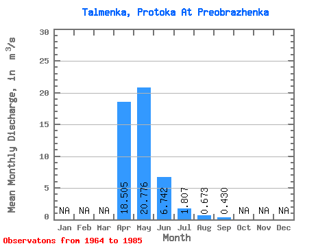
| Mean | 18.50 | 20.78 | 6.74 | 1.81 | 0.67 | 0.43 | |||||||
| Standard Deviation | 7.89 | 12.56 | 5.18 | 1.37 | 0.50 | ||||||||
| Min | 2.96 | 3.47 | 0.41 | 0.13 | 0.09 | 0.43 | |||||||
| Max | 32.90 | 43.80 | 20.10 | 5.07 | 1.47 | 0.43 | |||||||
| Coefficient of Variation | 0.43 | 0.60 | 0.77 | 0.76 | 0.74 |
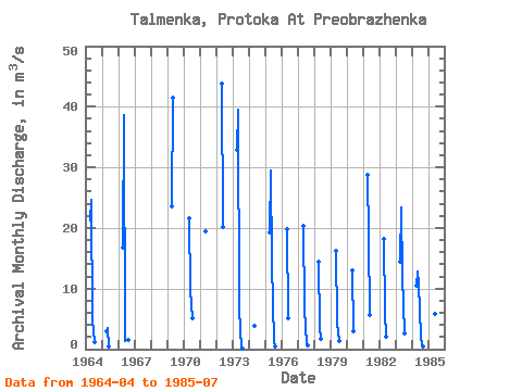
| Year | Jan | Feb | Mar | Apr | May | Jun | Jul | Aug | Sep | Oct | Nov | Dec | Annual | 1964 | 21.20 | 24.70 | 4.79 | 1.13 | 1965 | 2.96 | 3.47 | 0.41 | 1966 | 16.80 | 38.60 | 1.43 | 1.45 | 1.47 | 1967 | 1969 | 23.50 | 41.50 | 1970 | 21.60 | 9.83 | 5.07 | 1971 | 19.50 | 1972 | 43.80 | 20.10 | 1973 | 32.90 | 39.50 | 6.50 | 0.13 | 0.09 | 1974 | 3.91 | 1975 | 19.30 | 29.40 | 14.00 | 1.14 | 0.51 | 1976 | 19.80 | 5.11 | 1977 | 20.30 | 6.76 | 0.75 | 0.66 | 1978 | 14.50 | 3.61 | 1.79 | 1979 | 16.30 | 4.38 | 1.37 | 1980 | 13.00 | 2.93 | 1981 | 28.70 | 18.30 | 5.67 | 1982 | 18.20 | 6.04 | 2.10 | 1983 | 14.50 | 23.40 | 12.10 | 2.68 | 1984 | 10.50 | 12.80 | 10.90 | 1.98 | 0.64 | 0.43 | 1985 | 19.00 | 16.00 | 5.82 | 2.37 |
|---|
 Return to R-Arctic Net Home Page