|
|
|||||||||||||||||
| Point ID: 8563 | Downloads | Plots | Site Data | Code: 11101 |
|
|
|||||||||||||||||
| Download | |
|---|---|
| Site Descriptor Information | Site Time Series Data |
| Link to all available data | |
| View: | Time Series | All |
| Units: | mm |
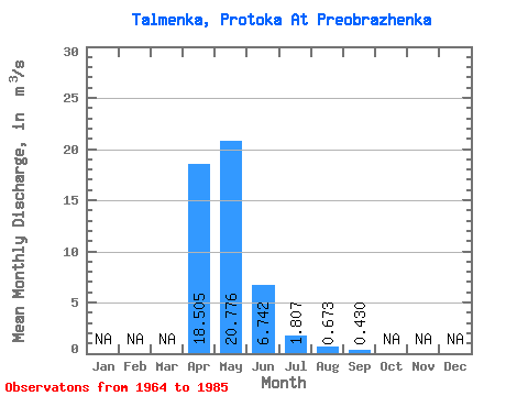
| Statistic | Jan | Feb | Mar | Apr | May | Jun | Jul | Aug | Sep | Oct | Nov | Dec | Annual |
|---|---|---|---|---|---|---|---|---|---|---|---|---|---|
| Mean | 18.50 | 20.78 | 6.74 | 1.81 | 0.67 | 0.43 | |||||||
| Standard Deviation | 7.89 | 12.56 | 5.18 | 1.37 | 0.50 | ||||||||
| Min | 2.96 | 3.47 | 0.41 | 0.13 | 0.09 | 0.43 | |||||||
| Max | 32.90 | 43.80 | 20.10 | 5.07 | 1.47 | 0.43 | |||||||
| Coefficient of Variation | 0.43 | 0.60 | 0.77 | 0.76 | 0.74 |
 Return to R-Arctic Net Home Page