|
|
|||||||||||||||||
| Point ID: 8547 | Downloads | Plots | Site Data | Code: 11074 |
|
|
|||||||||||||||||
| Download | |
|---|---|
| Site Descriptor Information | Site Time Series Data |
| Link to all available data | |
| View: | Time Series | All |
| Units: | m3/s |
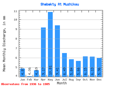
| Statistic | Jan | Feb | Mar | Apr | May | Jun | Jul | Aug | Sep | Oct | Nov | Dec | Annual |
|---|---|---|---|---|---|---|---|---|---|---|---|---|---|
| Mean | 4.87 | 4.10 | 4.69 | 9.17 | 10.81 | 9.41 | 6.49 | 5.84 | 5.66 | 6.15 | 6.13 | 5.96 | 82.75 |
| Standard Deviation | 1.93 | 1.26 | 0.98 | 7.89 | 8.41 | 7.73 | 3.86 | 3.34 | 3.41 | 2.48 | 3.20 | 2.80 | 34.45 |
| Min | 2.18 | 2.22 | 2.94 | 2.84 | 1.60 | 1.55 | 1.56 | 1.59 | 1.51 | 3.65 | 2.92 | 2.69 | 50.29 |
| Max | 10.16 | 7.04 | 6.80 | 34.53 | 39.25 | 35.51 | 19.23 | 15.83 | 15.03 | 13.60 | 16.74 | 11.67 | 185.01 |
| Coefficient of Variation | 0.40 | 0.31 | 0.21 | 0.86 | 0.78 | 0.82 | 0.59 | 0.57 | 0.60 | 0.40 | 0.52 | 0.47 | 0.42 |
 Return to R-Arctic Net Home Page