|
|
|||||||||||||||||
| Point ID: 8547 | Downloads | Plots | Site Data | Code: 11074 |
|
|
|||||||||||||||||
| Download | |
|---|---|
| Site Descriptor Information | Site Time Series Data |
| Link to all available data | |
| View: | Time Series | All |
| Units: | mm |
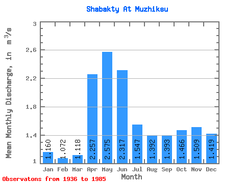
| Statistic | Jan | Feb | Mar | Apr | May | Jun | Jul | Aug | Sep | Oct | Nov | Dec | Annual |
|---|---|---|---|---|---|---|---|---|---|---|---|---|---|
| Mean | 1.16 | 1.07 | 1.12 | 2.26 | 2.58 | 2.32 | 1.55 | 1.39 | 1.39 | 1.47 | 1.51 | 1.42 | 1.67 |
| Standard Deviation | 0.46 | 0.33 | 0.23 | 1.94 | 2.00 | 1.90 | 0.92 | 0.80 | 0.84 | 0.59 | 0.79 | 0.67 | 0.70 |
| Min | 0.52 | 0.58 | 0.70 | 0.70 | 0.38 | 0.38 | 0.37 | 0.38 | 0.37 | 0.87 | 0.72 | 0.64 | 1.02 |
| Max | 2.42 | 1.84 | 1.62 | 8.50 | 9.35 | 8.74 | 4.58 | 3.77 | 3.70 | 3.24 | 4.12 | 2.78 | 3.74 |
| Coefficient of Variation | 0.40 | 0.31 | 0.21 | 0.86 | 0.78 | 0.82 | 0.59 | 0.57 | 0.60 | 0.40 | 0.52 | 0.47 | 0.42 |
 Return to R-Arctic Net Home Page