|
|
|||||||||||||||||
| Point ID: 8538 | Downloads | Plots | Site Data | Code: 10696 |
|
|
|||||||||||||||||
| Download | |
|---|---|
| Site Descriptor Information | Site Time Series Data |
| Link to all available data | |
|
|
| View: | Statistics | Time Series |
| Units: | mm |
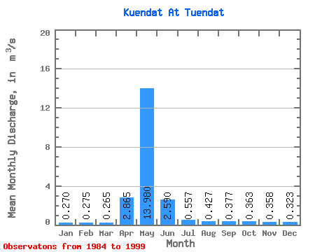
| Statistic | Jan | Feb | Mar | Apr | May | Jun | Jul | Aug | Sep | Oct | Nov | Dec | Annual |
|---|---|---|---|---|---|---|---|---|---|---|---|---|---|
| Mean | 0.27 | 0.28 | 0.27 | 2.87 | 13.98 | 2.59 | 0.56 | 0.43 | 0.38 | 0.36 | 0.36 | 0.32 | 1.50 |
| Standard Deviation | 0.21 | 0.23 | 0.22 | 0.18 | 11.64 | 2.13 | 0.36 | 0.25 | 0.23 | 0.23 | 0.23 | 0.22 | 1.59 |
| Min | 0.12 | 0.11 | 0.11 | 2.74 | 0.54 | 0.18 | 0.14 | 0.14 | 0.11 | 0.10 | 0.09 | 0.07 | 0.37 |
| Max | 0.42 | 0.44 | 0.42 | 2.99 | 20.80 | 4.24 | 0.79 | 0.58 | 0.54 | 0.52 | 0.51 | 0.46 | 2.63 |
| Coefficient of Variation | 0.79 | 0.85 | 0.83 | 0.06 | 0.83 | 0.82 | 0.65 | 0.58 | 0.62 | 0.63 | 0.64 | 0.68 | 1.06 |
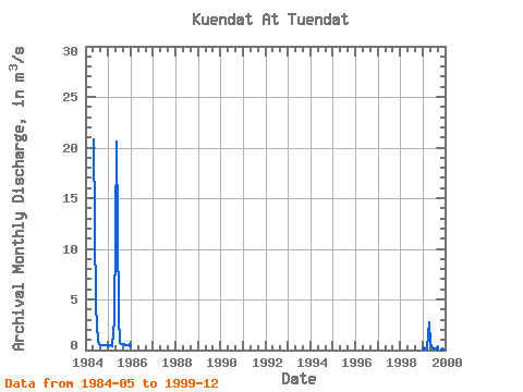
| Year | Jan | Feb | Mar | Apr | May | Jun | Jul | Aug | Sep | Oct | Nov | Dec | Annual | 1984 | 20.80 | 4.24 | 0.79 | 0.56 | 0.48 | 0.47 | 0.51 | 0.46 | 1985 | 0.42 | 0.44 | 0.42 | 2.99 | 20.60 | 3.35 | 0.74 | 0.58 | 0.54 | 0.52 | 0.47 | 0.44 | 2.63 | 1999 | 0.12 | 0.11 | 0.11 | 2.74 | 0.54 | 0.18 | 0.14 | 0.14 | 0.11 | 0.10 | 0.09 | 0.07 | 0.37 |
|---|
 Return to R-Arctic Net Home Page