|
|
|||||||||||||||||
| Point ID: 8538 | Downloads | Plots | Site Data | Code: 10696 |
|
|
|||||||||||||||||
| Download | |
|---|---|
| Site Descriptor Information | Site Time Series Data |
| Link to all available data | |
|
|
| View: | Statistics | Time Series |
| Units: | m3/s |
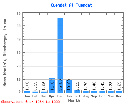
| Statistic | Jan | Feb | Mar | Apr | May | Jun | Jul | Aug | Sep | Oct | Nov | Dec | Annual |
|---|---|---|---|---|---|---|---|---|---|---|---|---|---|
| Mean | 1.08 | 1.00 | 1.06 | 11.07 | 55.80 | 10.01 | 2.22 | 1.70 | 1.46 | 1.45 | 1.38 | 1.29 | 70.48 |
| Standard Deviation | 0.85 | 0.85 | 0.88 | 0.68 | 46.45 | 8.24 | 1.44 | 0.99 | 0.90 | 0.92 | 0.89 | 0.88 | 74.99 |
| Min | 0.48 | 0.40 | 0.44 | 10.58 | 2.15 | 0.69 | 0.56 | 0.56 | 0.42 | 0.40 | 0.36 | 0.27 | 17.45 |
| Max | 1.68 | 1.60 | 1.68 | 11.55 | 83.01 | 16.38 | 3.15 | 2.31 | 2.09 | 2.08 | 1.97 | 1.84 | 123.50 |
| Coefficient of Variation | 0.79 | 0.85 | 0.83 | 0.06 | 0.83 | 0.82 | 0.65 | 0.58 | 0.62 | 0.63 | 0.64 | 0.68 | 1.06 |
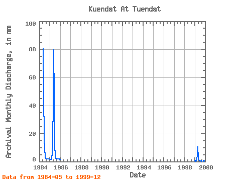
| Year | Jan | Feb | Mar | Apr | May | Jun | Jul | Aug | Sep | Oct | Nov | Dec | Annual | 1984 | 83.01 | 16.38 | 3.15 | 2.23 | 1.85 | 1.88 | 1.97 | 1.84 | 1985 | 1.68 | 1.60 | 1.68 | 11.55 | 82.22 | 12.94 | 2.95 | 2.31 | 2.09 | 2.08 | 1.82 | 1.76 | 123.50 | 1999 | 0.48 | 0.40 | 0.44 | 10.58 | 2.15 | 0.69 | 0.56 | 0.56 | 0.42 | 0.40 | 0.36 | 0.27 | 17.45 |
|---|
 Return to R-Arctic Net Home Page