|
|
|||||||||||||||||
| Point ID: 8535 | Downloads | Plots | Site Data | Code: 10693 |
|
|
|||||||||||||||||
| Download | |
|---|---|
| Site Descriptor Information | Site Time Series Data |
| Link to all available data | |
| View: | Time Series | All |
| Units: | m3/s |
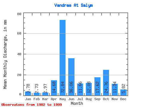
| Statistic | Jan | Feb | Mar | Apr | May | Jun | Jul | Aug | Sep | Oct | Nov | Dec | Annual |
|---|---|---|---|---|---|---|---|---|---|---|---|---|---|
| Mean | 3.78 | 2.76 | 2.97 | 14.68 | 72.83 | 36.06 | 11.65 | 12.07 | 17.61 | 24.75 | 11.34 | 5.82 | 214.09 |
| Standard Deviation | 1.50 | 1.06 | 1.16 | 19.02 | 26.41 | 29.90 | 7.10 | 8.53 | 11.56 | 19.22 | 6.47 | 2.93 | 67.84 |
| Min | 1.29 | 0.90 | 0.72 | 1.98 | 32.78 | 6.66 | 3.08 | 2.42 | 2.79 | 2.74 | 2.12 | 1.97 | 105.97 |
| Max | 6.45 | 4.73 | 5.12 | 65.25 | 134.52 | 118.87 | 26.63 | 37.40 | 40.52 | 66.18 | 22.94 | 11.07 | 318.62 |
| Coefficient of Variation | 0.40 | 0.39 | 0.39 | 1.29 | 0.36 | 0.83 | 0.61 | 0.71 | 0.66 | 0.78 | 0.57 | 0.50 | 0.32 |
 Return to R-Arctic Net Home Page