|
|
|||||||||||||||||
| Point ID: 8535 | Downloads | Plots | Site Data | Code: 10693 |
|
|
|||||||||||||||||
| Download | |
|---|---|
| Site Descriptor Information | Site Time Series Data |
| Link to all available data | |
| View: | Time Series | All |
| Units: | mm |
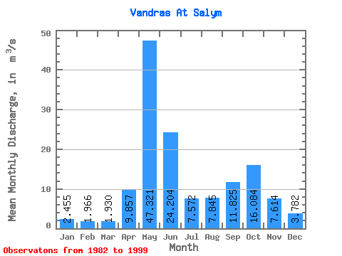
| Statistic | Jan | Feb | Mar | Apr | May | Jun | Jul | Aug | Sep | Oct | Nov | Dec | Annual |
|---|---|---|---|---|---|---|---|---|---|---|---|---|---|
| Mean | 2.46 | 1.97 | 1.93 | 9.86 | 47.32 | 24.20 | 7.57 | 7.84 | 11.82 | 16.08 | 7.61 | 3.78 | 11.80 |
| Standard Deviation | 0.97 | 0.76 | 0.75 | 12.77 | 17.16 | 20.07 | 4.62 | 5.54 | 7.76 | 12.49 | 4.34 | 1.91 | 3.74 |
| Min | 0.84 | 0.64 | 0.47 | 1.33 | 21.30 | 4.47 | 2.00 | 1.57 | 1.87 | 1.78 | 1.42 | 1.28 | 5.84 |
| Max | 4.19 | 3.37 | 3.33 | 43.80 | 87.40 | 79.80 | 17.30 | 24.30 | 27.20 | 43.00 | 15.40 | 7.19 | 17.57 |
| Coefficient of Variation | 0.40 | 0.39 | 0.39 | 1.29 | 0.36 | 0.83 | 0.61 | 0.71 | 0.66 | 0.78 | 0.57 | 0.50 | 0.32 |
 Return to R-Arctic Net Home Page