|
|
|||||||||||||||||
| Point ID: 8517 | Downloads | Plots | Site Data | Code: 10533 |
|
|
|||||||||||||||||
| Download | |
|---|---|
| Site Descriptor Information | Site Time Series Data |
| Link to all available data | |
|
|
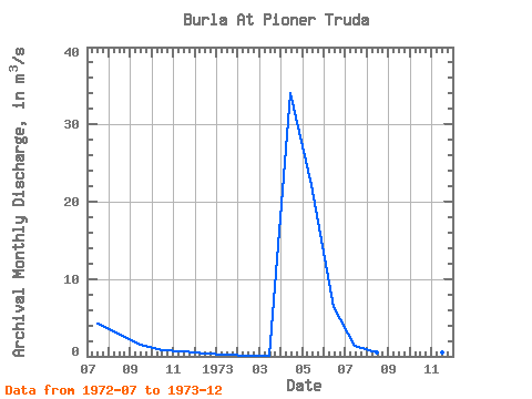
| View: | Statistics | Time Series |
| Units: | mm |
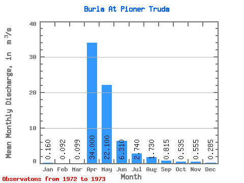
| Statistic | Jan | Feb | Mar | Apr | May | Jun | Jul | Aug | Sep | Oct | Nov | Dec | Annual |
|---|---|---|---|---|---|---|---|---|---|---|---|---|---|
| Mean | 0.16 | 0.09 | 0.10 | 34.00 | 22.10 | 6.31 | 2.74 | 1.73 | 0.81 | 0.54 | 0.56 | 0.28 | 5.48 |
| Standard Deviation | 2.04 | 1.67 | 0.88 | 0.42 | 0.15 | 0.05 | |||||||
| Min | 0.16 | 0.09 | 0.10 | 34.00 | 22.10 | 6.31 | 1.30 | 0.55 | 0.19 | 0.24 | 0.45 | 0.25 | 5.48 |
| Max | 0.16 | 0.09 | 0.10 | 34.00 | 22.10 | 6.31 | 4.18 | 2.91 | 1.44 | 0.83 | 0.66 | 0.32 | 5.48 |
| Coefficient of Variation | 0.74 | 0.96 | 1.08 | 0.78 | 0.27 | 0.17 |
| Year | Jan | Feb | Mar | Apr | May | Jun | Jul | Aug | Sep | Oct | Nov | Dec | Annual | 1972 | 4.18 | 2.91 | 1.44 | 0.83 | 0.66 | 0.32 | 1973 | 0.16 | 0.09 | 0.10 | 34.00 | 22.10 | 6.31 | 1.30 | 0.55 | 0.19 | 0.24 | 0.45 | 0.25 | 5.48 |
|---|
 Return to R-Arctic Net Home Page