|
|
|||||||||||||||||
| Point ID: 8517 | Downloads | Plots | Site Data | Code: 10533 |
|
|
|||||||||||||||||
| Download | |
|---|---|
| Site Descriptor Information | Site Time Series Data |
| Link to all available data | |
|
|
| View: | Statistics | Time Series |
| Units: | m3/s |
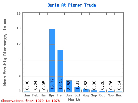
| Statistic | Jan | Feb | Mar | Apr | May | Jun | Jul | Aug | Sep | Oct | Nov | Dec | Annual |
|---|---|---|---|---|---|---|---|---|---|---|---|---|---|
| Mean | 0.08 | 0.04 | 0.05 | 15.77 | 10.59 | 2.93 | 1.31 | 0.83 | 0.38 | 0.26 | 0.26 | 0.14 | 30.93 |
| Standard Deviation | 0.98 | 0.80 | 0.41 | 0.20 | 0.07 | 0.02 | |||||||
| Min | 0.08 | 0.04 | 0.05 | 15.77 | 10.59 | 2.93 | 0.62 | 0.26 | 0.09 | 0.12 | 0.21 | 0.12 | 30.93 |
| Max | 0.08 | 0.04 | 0.05 | 15.77 | 10.59 | 2.93 | 2.00 | 1.39 | 0.67 | 0.40 | 0.31 | 0.15 | 30.93 |
| Coefficient of Variation | 0.74 | 0.96 | 1.08 | 0.78 | 0.27 | 0.17 |
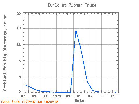
| Year | Jan | Feb | Mar | Apr | May | Jun | Jul | Aug | Sep | Oct | Nov | Dec | Annual | 1972 | 2.00 | 1.39 | 0.67 | 0.40 | 0.31 | 0.15 | 1973 | 0.08 | 0.04 | 0.05 | 15.77 | 10.59 | 2.93 | 0.62 | 0.26 | 0.09 | 0.12 | 0.21 | 0.12 | 30.93 |
|---|
 Return to R-Arctic Net Home Page