|
|
|||||||||||||||||
| Point ID: 8496 | Downloads | Plots | Site Data | Code: 10406 |
|
|
|||||||||||||||||
| Download | |
|---|---|
| Site Descriptor Information | Site Time Series Data |
| Link to all available data | |
|
|
| View: | Statistics | Time Series |
| Units: | mm |
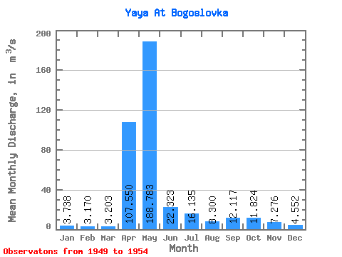
| Statistic | Jan | Feb | Mar | Apr | May | Jun | Jul | Aug | Sep | Oct | Nov | Dec | Annual |
|---|---|---|---|---|---|---|---|---|---|---|---|---|---|
| Mean | 3.74 | 3.17 | 3.20 | 107.55 | 188.78 | 22.32 | 16.14 | 8.30 | 12.12 | 11.82 | 7.28 | 4.55 | 32.18 |
| Standard Deviation | 0.46 | 0.76 | 1.11 | 91.07 | 80.77 | 14.42 | 11.43 | 4.64 | 8.51 | 5.05 | 2.65 | 0.70 | 3.79 |
| Min | 3.24 | 2.19 | 1.47 | 11.70 | 97.70 | 7.30 | 5.18 | 3.92 | 2.85 | 4.74 | 4.20 | 3.81 | 26.71 |
| Max | 4.37 | 3.96 | 4.25 | 204.00 | 285.00 | 39.20 | 29.90 | 16.70 | 26.60 | 17.00 | 11.40 | 5.41 | 36.75 |
| Coefficient of Variation | 0.12 | 0.24 | 0.35 | 0.85 | 0.43 | 0.65 | 0.71 | 0.56 | 0.70 | 0.43 | 0.36 | 0.15 | 0.12 |
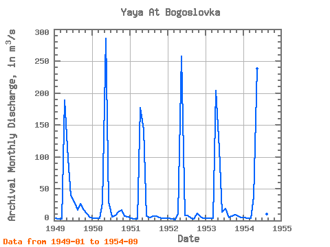
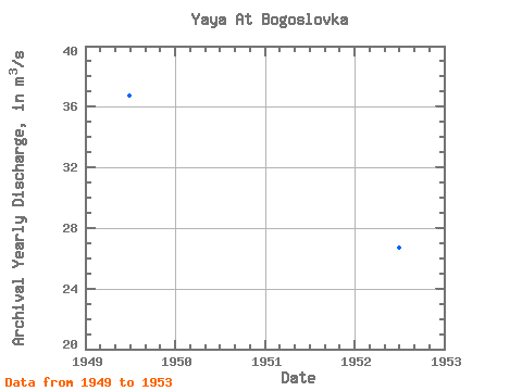
| Year | Jan | Feb | Mar | Apr | May | Jun | Jul | Aug | Sep | Oct | Nov | Dec | Annual | 1949 | 3.24 | 3.13 | 3.00 | 189.00 | 97.70 | 39.20 | 29.10 | 16.70 | 26.60 | 17.00 | 11.40 | 4.96 | 36.75 | 1950 | 3.90 | 3.96 | 4.24 | 26.90 | 285.00 | 29.40 | 5.83 | 7.60 | 13.60 | 16.20 | 7.46 | 5.41 | 34.12 | 1951 | 3.31 | 2.19 | 2.46 | 177.00 | 143.00 | 7.30 | 5.18 | 6.46 | 7.32 | 4.74 | 4.20 | 3.85 | 30.58 | 1952 | 3.50 | 2.34 | 1.47 | 11.70 | 257.00 | 7.94 | 8.20 | 3.92 | 2.85 | 11.80 | 5.98 | 3.81 | 26.71 | 1953 | 4.11 | 3.58 | 3.80 | 204.00 | 112.00 | 13.70 | 18.60 | 5.02 | 6.73 | 9.38 | 7.34 | 4.73 | 32.75 | 1954 | 4.37 | 3.82 | 4.25 | 36.70 | 238.00 | 36.40 | 29.90 | 10.10 | 15.60 |
|---|
 Return to R-Arctic Net Home Page