|
|
|||||||||||||||||
| Point ID: 8496 | Downloads | Plots | Site Data | Code: 10406 |
|
|
|||||||||||||||||
| Download | |
|---|---|
| Site Descriptor Information | Site Time Series Data |
| Link to all available data | |
|
|
| View: | Statistics | Time Series |
| Units: | m3/s |
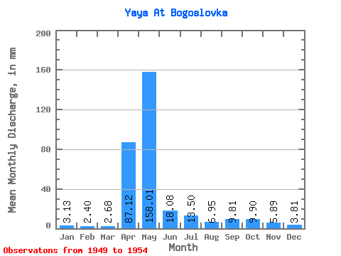
| Statistic | Jan | Feb | Mar | Apr | May | Jun | Jul | Aug | Sep | Oct | Nov | Dec | Annual |
|---|---|---|---|---|---|---|---|---|---|---|---|---|---|
| Mean | 3.13 | 2.42 | 2.68 | 87.12 | 157.99 | 18.08 | 13.50 | 6.95 | 9.81 | 9.89 | 5.89 | 3.81 | 317.42 |
| Standard Deviation | 0.38 | 0.58 | 0.93 | 73.77 | 67.60 | 11.68 | 9.56 | 3.88 | 6.89 | 4.23 | 2.15 | 0.59 | 37.39 |
| Min | 2.71 | 1.67 | 1.23 | 9.48 | 81.76 | 5.91 | 4.33 | 3.28 | 2.31 | 3.97 | 3.40 | 3.19 | 263.42 |
| Max | 3.66 | 3.02 | 3.56 | 165.24 | 238.51 | 31.75 | 25.02 | 13.98 | 21.55 | 14.23 | 9.23 | 4.53 | 362.47 |
| Coefficient of Variation | 0.12 | 0.24 | 0.35 | 0.85 | 0.43 | 0.65 | 0.71 | 0.56 | 0.70 | 0.43 | 0.36 | 0.15 | 0.12 |
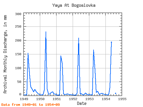
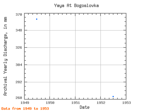
| Year | Jan | Feb | Mar | Apr | May | Jun | Jul | Aug | Sep | Oct | Nov | Dec | Annual | 1949 | 2.71 | 2.39 | 2.51 | 153.09 | 81.76 | 31.75 | 24.35 | 13.98 | 21.55 | 14.23 | 9.23 | 4.15 | 362.47 | 1950 | 3.26 | 3.02 | 3.55 | 21.79 | 238.51 | 23.81 | 4.88 | 6.36 | 11.02 | 13.56 | 6.04 | 4.53 | 336.56 | 1951 | 2.77 | 1.67 | 2.06 | 143.37 | 119.67 | 5.91 | 4.33 | 5.41 | 5.93 | 3.97 | 3.40 | 3.22 | 301.64 | 1952 | 2.93 | 1.78 | 1.23 | 9.48 | 215.08 | 6.43 | 6.86 | 3.28 | 2.31 | 9.88 | 4.84 | 3.19 | 263.42 | 1953 | 3.44 | 2.73 | 3.18 | 165.24 | 93.73 | 11.10 | 15.57 | 4.20 | 5.45 | 7.85 | 5.95 | 3.96 | 322.99 | 1954 | 3.66 | 2.91 | 3.56 | 29.73 | 199.18 | 29.48 | 25.02 | 8.45 | 12.64 |
|---|
 Return to R-Arctic Net Home Page