|
|
|||||||||||||||||
| Point ID: 8469 | Downloads | Plots | Site Data | Code: 10267 |
|
|
|||||||||||||||||
| Download | |
|---|---|
| Site Descriptor Information | Site Time Series Data |
| Link to all available data | |
|
|
| View: | Statistics | Time Series |
| Units: | mm |
| Statistic | Jan | Feb | Mar | Apr | May | Jun | Jul | Aug | Sep | Oct | Nov | Dec | Annual |
|---|---|---|---|---|---|---|---|---|---|---|---|---|---|
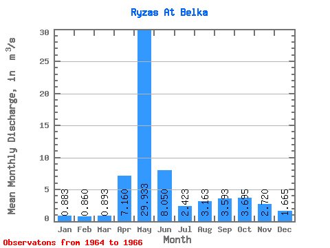
| Mean | 0.88 | 0.86 | 0.89 | 7.16 | 29.93 | 8.05 | 2.42 | 3.16 | 3.59 | 3.69 | 2.72 | 1.67 | 4.56 |
| Standard Deviation | 0.24 | 0.14 | 0.10 | 2.66 | 8.19 | 6.47 | 1.08 | 1.39 | 2.48 | 1.34 | 0.11 | 0.15 | 0.14 |
| Min | 0.60 | 0.73 | 0.81 | 5.28 | 24.10 | 2.59 | 1.44 | 2.00 | 1.92 | 2.75 | 2.64 | 1.56 | 4.47 |
| Max | 1.03 | 1.00 | 1.00 | 10.20 | 39.30 | 15.20 | 3.58 | 4.70 | 6.44 | 4.64 | 2.80 | 1.77 | 4.66 |
| Coefficient of Variation | 0.28 | 0.16 | 0.11 | 0.37 | 0.27 | 0.80 | 0.45 | 0.44 | 0.69 | 0.36 | 0.04 | 0.09 | 0.03 |
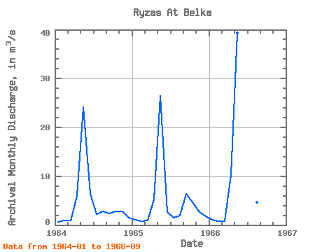
| Year | Jan | Feb | Mar | Apr | May | Jun | Jul | Aug | Sep | Oct | Nov | Dec | Annual | 1964 | 0.60 | 1.00 | 1.00 | 6.00 | 24.10 | 6.36 | 2.25 | 2.79 | 2.42 | 2.75 | 2.80 | 1.56 | 4.47 | 1965 | 1.02 | 0.85 | 0.87 | 5.28 | 26.40 | 2.59 | 1.44 | 2.00 | 6.44 | 4.64 | 2.64 | 1.77 | 4.66 | 1966 | 1.03 | 0.73 | 0.81 | 10.20 | 39.30 | 15.20 | 3.58 | 4.70 | 1.92 |
|---|
 Return to R-Arctic Net Home Page