|
|
|||||||||||||||||
| Point ID: 8469 | Downloads | Plots | Site Data | Code: 10267 |
|
|
|||||||||||||||||
| Download | |
|---|---|
| Site Descriptor Information | Site Time Series Data |
| Link to all available data | |
|
|
| View: | Statistics | Time Series |
| Units: | m3/s |
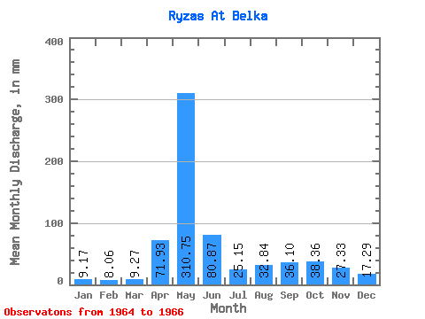
| Statistic | Jan | Feb | Mar | Apr | May | Jun | Jul | Aug | Sep | Oct | Nov | Dec | Annual |
|---|---|---|---|---|---|---|---|---|---|---|---|---|---|
| Mean | 9.17 | 8.13 | 9.27 | 71.93 | 310.70 | 80.87 | 25.15 | 32.84 | 36.10 | 38.35 | 27.33 | 17.28 | 558.47 |
| Standard Deviation | 2.55 | 1.28 | 1.01 | 26.70 | 85.04 | 65.03 | 11.21 | 14.41 | 24.89 | 13.87 | 1.14 | 1.54 | 16.65 |
| Min | 6.23 | 6.90 | 8.41 | 53.05 | 250.15 | 26.02 | 14.95 | 20.76 | 19.29 | 28.55 | 26.52 | 16.19 | 546.69 |
| Max | 10.69 | 9.46 | 10.38 | 102.47 | 407.93 | 152.71 | 37.16 | 48.78 | 64.70 | 48.16 | 28.13 | 18.37 | 570.24 |
| Coefficient of Variation | 0.28 | 0.16 | 0.11 | 0.37 | 0.27 | 0.80 | 0.45 | 0.44 | 0.69 | 0.36 | 0.04 | 0.09 | 0.03 |
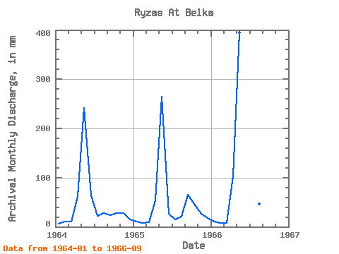
| Year | Jan | Feb | Mar | Apr | May | Jun | Jul | Aug | Sep | Oct | Nov | Dec | Annual | 1964 | 6.23 | 9.46 | 10.38 | 60.28 | 250.15 | 63.90 | 23.36 | 28.96 | 24.31 | 28.55 | 28.13 | 16.19 | 546.69 | 1965 | 10.59 | 8.04 | 9.03 | 53.05 | 274.03 | 26.02 | 14.95 | 20.76 | 64.70 | 48.16 | 26.52 | 18.37 | 570.24 | 1966 | 10.69 | 6.90 | 8.41 | 102.47 | 407.93 | 152.71 | 37.16 | 48.78 | 19.29 |
|---|
 Return to R-Arctic Net Home Page