|
|
|||||||||||||||||
| Point ID: 8467 | Downloads | Plots | Site Data | Code: 10261 |
|
|
|||||||||||||||||
| Download | |
|---|---|
| Site Descriptor Information | Site Time Series Data |
| Link to all available data | |
|
|
| View: | Statistics | Time Series |
| Units: | mm |
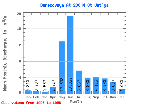
| Statistic | Jan | Feb | Mar | Apr | May | Jun | Jul | Aug | Sep | Oct | Nov | Dec | Annual |
|---|---|---|---|---|---|---|---|---|---|---|---|---|---|
| Mean | 0.81 | 0.70 | 0.54 | 1.71 | 12.83 | 19.07 | 5.67 | 3.88 | 4.12 | 3.79 | 3.00 | 1.08 | 4.16 |
| Standard Deviation | 0.17 | 0.11 | 0.20 | 0.70 | 2.61 | 9.62 | 3.53 | 0.67 | 1.35 | 0.86 | 0.31 | 0.26 | 0.13 |
| Min | 0.61 | 0.57 | 0.31 | 1.12 | 10.60 | 12.40 | 3.39 | 3.28 | 3.16 | 3.18 | 2.78 | 0.90 | 4.07 |
| Max | 0.92 | 0.77 | 0.67 | 2.48 | 15.70 | 30.10 | 9.73 | 4.60 | 5.07 | 4.40 | 3.22 | 1.26 | 4.25 |
| Coefficient of Variation | 0.21 | 0.16 | 0.37 | 0.41 | 0.20 | 0.51 | 0.62 | 0.17 | 0.33 | 0.23 | 0.10 | 0.24 | 0.03 |
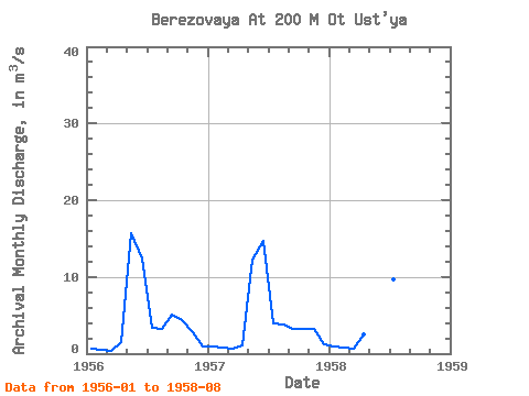
| Year | Jan | Feb | Mar | Apr | May | Jun | Jul | Aug | Sep | Oct | Nov | Dec | Annual | 1956 | 0.61 | 0.57 | 0.31 | 1.53 | 15.70 | 12.40 | 3.39 | 3.28 | 5.07 | 4.40 | 2.78 | 0.90 | 4.25 | 1957 | 0.92 | 0.77 | 0.63 | 1.12 | 12.20 | 14.70 | 3.88 | 3.76 | 3.16 | 3.18 | 3.22 | 1.26 | 4.07 | 1958 | 0.90 | 0.76 | 0.67 | 2.48 | 10.60 | 30.10 | 9.73 | 4.60 |
|---|
 Return to R-Arctic Net Home Page