|
|
|||||||||||||||||
| Point ID: 8467 | Downloads | Plots | Site Data | Code: 10261 |
|
|
|||||||||||||||||
| Download | |
|---|---|
| Site Descriptor Information | Site Time Series Data |
| Link to all available data | |
|
|
| View: | Statistics | Time Series |
| Units: | m3/s |
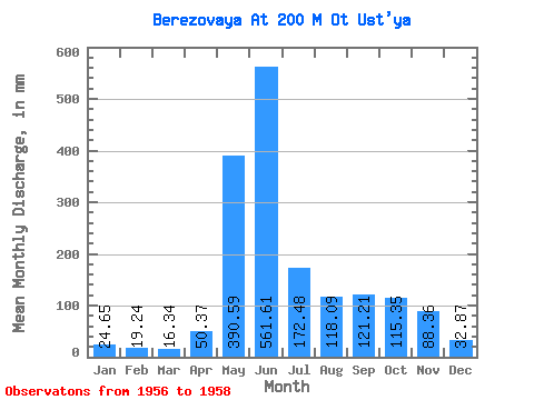
| Statistic | Jan | Feb | Mar | Apr | May | Jun | Jul | Aug | Sep | Oct | Nov | Dec | Annual |
|---|---|---|---|---|---|---|---|---|---|---|---|---|---|
| Mean | 24.65 | 19.41 | 16.33 | 50.37 | 390.54 | 561.60 | 172.45 | 118.08 | 121.20 | 115.34 | 88.36 | 32.87 | 1490.43 |
| Standard Deviation | 5.28 | 3.12 | 6.00 | 20.55 | 79.38 | 283.47 | 107.35 | 20.33 | 39.78 | 26.25 | 9.16 | 7.75 | 45.22 |
| Min | 18.56 | 15.80 | 9.43 | 32.99 | 322.58 | 365.24 | 103.16 | 99.82 | 93.08 | 96.77 | 81.88 | 27.39 | 1458.45 |
| Max | 28.00 | 21.35 | 20.39 | 73.05 | 477.78 | 886.58 | 296.10 | 139.99 | 149.34 | 133.90 | 94.84 | 38.34 | 1522.41 |
| Coefficient of Variation | 0.21 | 0.16 | 0.37 | 0.41 | 0.20 | 0.51 | 0.62 | 0.17 | 0.33 | 0.23 | 0.10 | 0.24 | 0.03 |
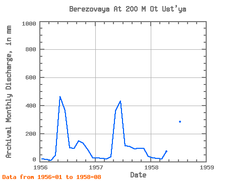
| Year | Jan | Feb | Mar | Apr | May | Jun | Jul | Aug | Sep | Oct | Nov | Dec | Annual | 1956 | 18.56 | 15.80 | 9.43 | 45.06 | 477.78 | 365.24 | 103.16 | 99.82 | 149.34 | 133.90 | 81.88 | 27.39 | 1522.41 | 1957 | 28.00 | 21.35 | 19.17 | 32.99 | 371.27 | 432.98 | 118.08 | 114.42 | 93.08 | 96.77 | 94.84 | 38.34 | 1458.45 | 1958 | 27.39 | 21.07 | 20.39 | 73.05 | 322.58 | 886.58 | 296.10 | 139.99 |
|---|
 Return to R-Arctic Net Home Page