|
|
|||||||||||||||||
| Point ID: 8462 | Downloads | Plots | Site Data | Code: 10230 |
|
|
|||||||||||||||||
| Download | |
|---|---|
| Site Descriptor Information | Site Time Series Data |
| Link to all available data | |
|
|
| View: | Statistics | Time Series |
| Units: | mm |
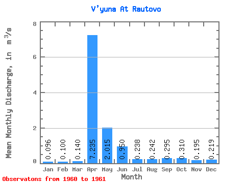
| Statistic | Jan | Feb | Mar | Apr | May | Jun | Jul | Aug | Sep | Oct | Nov | Dec | Annual |
|---|---|---|---|---|---|---|---|---|---|---|---|---|---|
| Mean | 0.10 | 0.10 | 0.14 | 7.24 | 2.02 | 0.95 | 0.24 | 0.24 | 0.29 | 0.31 | 0.20 | 0.22 | 1.00 |
| Standard Deviation | 0.03 | 0.00 | 0.01 | 0.16 | 0.71 | 0.59 | 0.27 | 0.22 | 0.09 | 0.04 | 0.02 | 0.20 | 0.16 |
| Min | 0.07 | 0.10 | 0.13 | 7.12 | 1.51 | 0.53 | 0.04 | 0.08 | 0.23 | 0.28 | 0.18 | 0.08 | 0.89 |
| Max | 0.12 | 0.10 | 0.15 | 7.35 | 2.52 | 1.37 | 0.43 | 0.40 | 0.36 | 0.34 | 0.21 | 0.36 | 1.11 |
| Coefficient of Variation | 0.35 | 0.00 | 0.10 | 0.02 | 0.35 | 0.62 | 1.15 | 0.93 | 0.31 | 0.14 | 0.11 | 0.92 | 0.16 |
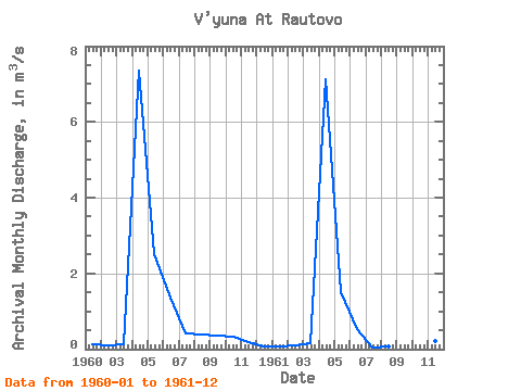
| Year | Jan | Feb | Mar | Apr | May | Jun | Jul | Aug | Sep | Oct | Nov | Dec | Annual | 1960 | 0.12 | 0.10 | 0.13 | 7.35 | 2.52 | 1.37 | 0.43 | 0.40 | 0.36 | 0.34 | 0.18 | 0.08 | 1.11 | 1961 | 0.07 | 0.10 | 0.15 | 7.12 | 1.51 | 0.53 | 0.04 | 0.08 | 0.23 | 0.28 | 0.21 | 0.36 | 0.89 |
|---|
 Return to R-Arctic Net Home Page