|
|
|||||||||||||||||
| Point ID: 8462 | Downloads | Plots | Site Data | Code: 10230 |
|
|
|||||||||||||||||
| Download | |
|---|---|
| Site Descriptor Information | Site Time Series Data |
| Link to all available data | |
|
|
| View: | Statistics | Time Series |
| Units: | m3/s |
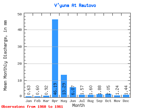
| Statistic | Jan | Feb | Mar | Apr | May | Jun | Jul | Aug | Sep | Oct | Nov | Dec | Annual |
|---|---|---|---|---|---|---|---|---|---|---|---|---|---|
| Mean | 0.63 | 0.60 | 0.92 | 46.19 | 13.29 | 6.07 | 1.57 | 1.59 | 1.88 | 2.04 | 1.25 | 1.44 | 77.95 |
| Standard Deviation | 0.22 | 0.00 | 0.09 | 1.04 | 4.71 | 3.79 | 1.80 | 1.48 | 0.59 | 0.28 | 0.14 | 1.32 | 12.31 |
| Min | 0.47 | 0.60 | 0.86 | 45.46 | 9.96 | 3.38 | 0.30 | 0.55 | 1.47 | 1.85 | 1.15 | 0.51 | 69.25 |
| Max | 0.79 | 0.60 | 0.99 | 46.92 | 16.62 | 8.75 | 2.84 | 2.64 | 2.30 | 2.24 | 1.34 | 2.38 | 86.65 |
| Coefficient of Variation | 0.35 | 0.00 | 0.10 | 0.02 | 0.35 | 0.62 | 1.15 | 0.93 | 0.31 | 0.14 | 0.11 | 0.92 | 0.16 |
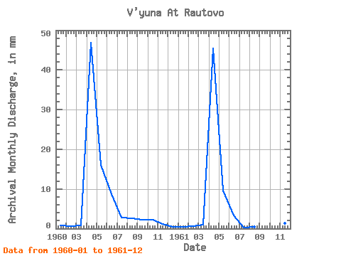
| Year | Jan | Feb | Mar | Apr | May | Jun | Jul | Aug | Sep | Oct | Nov | Dec | Annual | 1960 | 0.79 | 0.60 | 0.86 | 46.92 | 16.62 | 8.75 | 2.84 | 2.64 | 2.30 | 2.24 | 1.15 | 0.51 | 86.65 | 1961 | 0.47 | 0.60 | 0.99 | 45.46 | 9.96 | 3.38 | 0.30 | 0.55 | 1.47 | 1.85 | 1.34 | 2.38 | 69.25 |
|---|
 Return to R-Arctic Net Home Page