|
|
|||||||||||||||||
| Point ID: 8451 | Downloads | Plots | Site Data | Code: 10194 |
|
|
|||||||||||||||||
| Download | |
|---|---|
| Site Descriptor Information | Site Time Series Data |
| Link to all available data | |
|
|
| View: | Statistics | Time Series |
| Units: | mm |
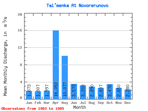
| Statistic | Jan | Feb | Mar | Apr | May | Jun | Jul | Aug | Sep | Oct | Nov | Dec | Annual |
|---|---|---|---|---|---|---|---|---|---|---|---|---|---|
| Mean | 1.87 | 1.81 | 2.00 | 16.05 | 10.08 | 3.57 | 3.20 | 2.89 | 2.61 | 3.47 | 2.65 | 2.28 | 4.37 |
| Standard Deviation | 0.62 | 0.81 | 0.88 | 9.65 | 3.25 | 0.34 | 0.94 | 0.78 | 0.24 | 0.88 | 0.58 | 0.62 | 0.64 |
| Min | 1.24 | 0.98 | 1.10 | 5.96 | 6.33 | 3.23 | 2.40 | 2.21 | 2.34 | 2.63 | 1.99 | 1.70 | 3.67 |
| Max | 2.48 | 2.60 | 2.85 | 25.20 | 12.20 | 3.91 | 4.24 | 3.74 | 2.80 | 4.38 | 3.08 | 2.93 | 4.92 |
| Coefficient of Variation | 0.33 | 0.45 | 0.44 | 0.60 | 0.32 | 0.10 | 0.29 | 0.27 | 0.09 | 0.25 | 0.22 | 0.27 | 0.15 |
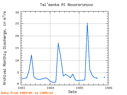
| Year | Jan | Feb | Mar | Apr | May | Jun | Jul | Aug | Sep | Oct | Nov | Dec | Annual | 1983 | 2.48 | 2.60 | 2.85 | 5.96 | 12.20 | 3.23 | 2.40 | 2.21 | 2.34 | 2.63 | 2.88 | 2.21 | 3.67 | 1984 | 1.24 | 0.98 | 1.10 | 17.00 | 11.70 | 3.58 | 4.24 | 3.74 | 2.80 | 4.38 | 1.99 | 1.70 | 4.54 | 1985 | 1.90 | 1.84 | 2.04 | 25.20 | 6.33 | 3.91 | 2.97 | 2.72 | 2.68 | 3.40 | 3.08 | 2.93 | 4.92 |
|---|
 Return to R-Arctic Net Home Page