|
|
|||||||||||||||||
| Point ID: 8451 | Downloads | Plots | Site Data | Code: 10194 |
|
|
|||||||||||||||||
| Download | |
|---|---|
| Site Descriptor Information | Site Time Series Data |
| Link to all available data | |
|
|
| View: | Statistics | Time Series |
| Units: | m3/s |
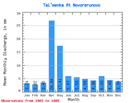
| Statistic | Jan | Feb | Mar | Apr | May | Jun | Jul | Aug | Sep | Oct | Nov | Dec | Annual |
|---|---|---|---|---|---|---|---|---|---|---|---|---|---|
| Mean | 3.24 | 2.84 | 3.45 | 26.84 | 17.41 | 5.98 | 5.54 | 4.99 | 4.36 | 6.00 | 4.43 | 3.94 | 89.05 |
| Standard Deviation | 1.07 | 1.28 | 1.51 | 16.14 | 5.62 | 0.57 | 1.63 | 1.35 | 0.40 | 1.52 | 0.97 | 1.07 | 13.06 |
| Min | 2.14 | 1.54 | 1.90 | 9.97 | 10.94 | 5.40 | 4.15 | 3.82 | 3.91 | 4.54 | 3.33 | 2.94 | 74.64 |
| Max | 4.29 | 4.09 | 4.92 | 42.14 | 21.08 | 6.54 | 7.33 | 6.46 | 4.68 | 7.57 | 5.15 | 5.06 | 100.11 |
| Coefficient of Variation | 0.33 | 0.45 | 0.44 | 0.60 | 0.32 | 0.10 | 0.29 | 0.27 | 0.09 | 0.25 | 0.22 | 0.27 | 0.15 |
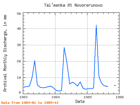
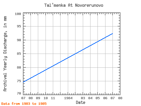
| Year | Jan | Feb | Mar | Apr | May | Jun | Jul | Aug | Sep | Oct | Nov | Dec | Annual | 1983 | 4.29 | 4.09 | 4.92 | 9.97 | 21.08 | 5.40 | 4.15 | 3.82 | 3.91 | 4.54 | 4.82 | 3.82 | 74.64 | 1984 | 2.14 | 1.54 | 1.90 | 28.43 | 20.21 | 5.99 | 7.33 | 6.46 | 4.68 | 7.57 | 3.33 | 2.94 | 92.39 | 1985 | 3.28 | 2.90 | 3.52 | 42.14 | 10.94 | 6.54 | 5.13 | 4.70 | 4.48 | 5.87 | 5.15 | 5.06 | 100.11 |
|---|
 Return to R-Arctic Net Home Page